|
THE COON FAMILY HIKING CLUB
POWERED BY DWLZ.com |

|
| [ Home ] [ DWLZ ] [ Message Board ] [ Restaurants ] [ Order Cookbooks ] [ Dotti's Newsletter ] [ Support Dotti ] [ FAQs ] [ Email Dotti ] [ Email Al ] |
THINGS YOU
MIGHT ENJOY
LARCH MOUNTAIN
Mini-hike
6/30/2013
The Coon Family Hiking Club
Official Hike
Began: 17:05
Ended: 17:55
0.6 miles - 50 minutes
|
Ten years ago, Dotti and I first began a hike from the parking lot at the top of Larch mountain. We had been doing a lot of hiking in 2003, and were in at least passible shape. Larch Mountain Hike #1 turned out to be a very trying ordeal. We bit off more than we could chew.
We felt so badly about how it went, that we decided to try and “crawl back into the saddle” and a few years later, in 2007, we tried it again, but with a twist: Larch Mountain Hike #2. We drove two cars over to the falls. We parked the car at the bottom of the falls and then drove the van all the way to the parking lot at the top of Larch Mountain. We then set out to walk all the way from there to the bottom of Multnomah Falls. [You will find some nice topographical maps in the 2007 hike to show the layout of Larch Mountain, all the way down to the Gorge.] Well, frankly, we were not happy with how hike number 2 went either. It was more than we were up for. So, this time we hoped we would be a bit more conservative, and just walk up from the upper Larch Mountain parking lot to the peak of the mountain, at Sherrard Point. We have been up to Sherrard Point several times. Our first trip up was on our Larch Mountain Hike #1 on July 12, 2003. We later did pretty much the same thing we did on this mini-hike, on August 9, 2007, with a stop at Chanticleer Point, and then made our way up to Sherrard Point. One of our primary reasons for moving back to Vancouver was to be near the Columbia River Gorge and all the hiking trails. But we have a long hard road of recovery to get back to the place we were in 2003, when we did all those hikes. Dotti and I are both overweight. This makes hiking much tougher. Dotti’s hips were both destroyed by arthritis, and have been replaced. (See Straight From the Hip and The Next Step. ) And while this has removed her pain, she still has a long ways to go to get back to where she was in 2003. I also have not been exercising as I should. So, we have much work to do. However, this mini-hike seemed to be in our reach, even with our current limitations. Our dear friend Joan, from Wisconsin was with us as well (see Dotti and Al meet Joan for our 2001 meeting and first hike together!), and you might remember that she has joined us before on a hike in 2004, on our Silver Falls Park Hike #4. Also, it was Joan’s birthday, and she was eager to get out and take some pictures, and what better place than the Columbia River Gorge? So off we went! We headed across the Columbia River on the Glenn L. Jackson Memorial Bridge, which carries I-205 from Washington to Oregon, and the hit I-84 East heading out to the Gorge. 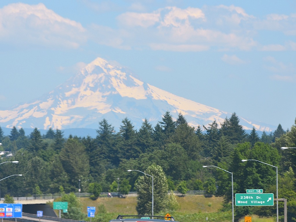 As we hit the Wood Village exit, Exit 16, Dotti snapped this picture of Mt. Hood. I have taken that exit an uncountable number of times, when I was onsite over at one my company’s customers’ campus. So many memories are entangled with this area of the country for us. Most of them are very good ones. And the entire time we lived in Spokane, I very much missed seeing this lovely mountain. It feels good to be back home!
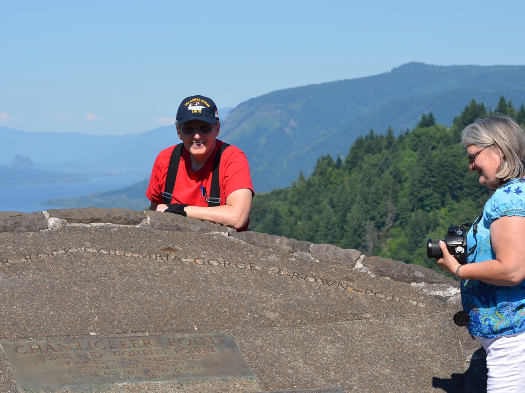
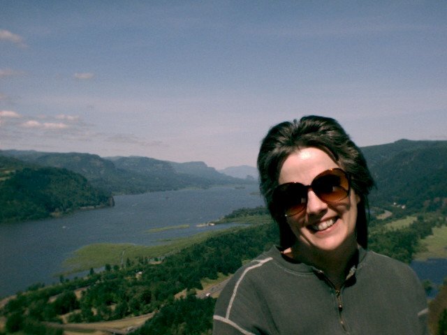
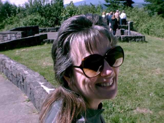
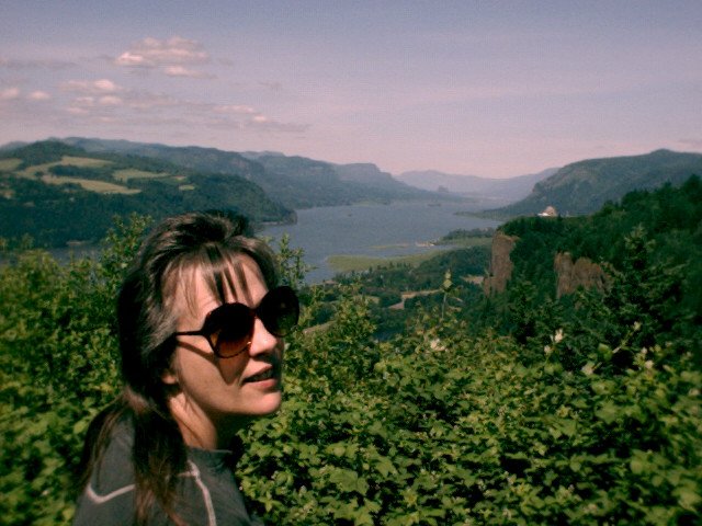
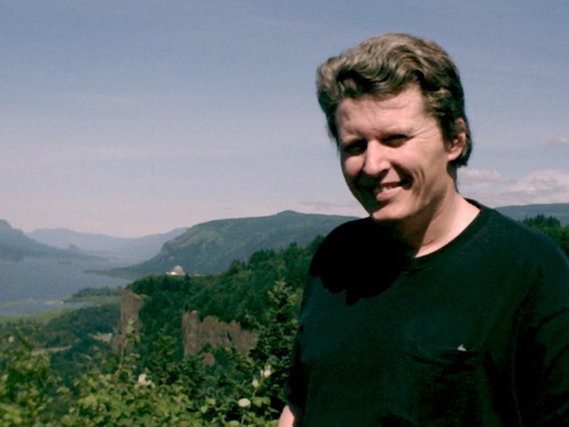
Something I find interesting is the fact that mile markers on I-84 indicate the distance to the Willamette River. At Exit 16, you are 16 miles east of the Willamette River, home of the Portland Spirit, and marking the edge of the Downtown area of Portland. We got off at the Corbett Exit # 22, and drove up the hill to get onto the Columbia Gorge Scenic Highway. We drove east on the highway until we hit Chanticleer Point, maintained by the Portland Women’s Forum, and officially named The Women’s Forum Viewpoint, on the left side of the road. It is a great spot for a view of the Gorge and so we have stopped there many times. At 705 feet in elevation, it is the first good viewing point for the Columbia River Gorge coming from Portland. The Columbia River forms a bend with Chanticleer Point forming the unyielding cliff of rock that turned it from flowing southwest, to directly due west. Far below the Columbia flows smoothly, and at a lower level than when Lewis and Clark first laid eyes on this area in 1805; the Bonneville Dam just upriver sees to that. Its surface is only a few feet above sea level at this point. The land beside the river along the stretch visible from this viewpoint, was river bottom at one time, but today it carries Interstate 84 and the railroad. Here are some pictures we took back in 1999, and they are some of my very favorite pictures of Dotti that I have! (I snuck one of me in there as well.  ) )
|
||||||||||
|
||||||||||
 Joan took this photo of the information plaque at Chanticleer Point. It discusses the geology of the place, with the massive flow of lava that covered the area and then the massive Bretz Floods that ripped out the sides of the Gorge, leaving a large number of beautiful waterfalls hanging in space. Joan took this photo of the information plaque at Chanticleer Point. It discusses the geology of the place, with the massive flow of lava that covered the area and then the massive Bretz Floods that ripped out the sides of the Gorge, leaving a large number of beautiful waterfalls hanging in space.
|
||||||||||
 I snapped this shot over Joan’s head, as she took a photo of the Gorge and Crown Point off to the right. We would be visiting that building a bit later on. We are looking upriver on the Columbia River. Interstate 84, which was named Interstate 80 North, back in 1974 when I first met Dotti, is running along beside the river. I snapped this shot over Joan’s head, as she took a photo of the Gorge and Crown Point off to the right. We would be visiting that building a bit later on. We are looking upriver on the Columbia River. Interstate 84, which was named Interstate 80 North, back in 1974 when I first met Dotti, is running along beside the river.
|
||||||||||
 This is the Columbia River Gorge looking east. The Vista House is that building on the right, perched on the top of the protruding basalt ledge, name Crown point.
|
||||||||||
 Using a zoom telephoto lens you can see a much closer view of Crown Point, and off in the distance is the Bonneville Dam, and on the left is Beacon Rock.
|
||||||||||
 Vista House, on Crown Point, at an elevation of 733 feet, just slightly above where we were standing. With a zoom lens it brought the beautiful building much closer. It also pulled in the tall basalt cliffs behind it, and a bit of the Bonneville Dam into view. The rich forest, thick and mixed with deciduous and evergreen flora, covers the volcanic rock like a winter’s coat, in summer, and ironically thinning slightly during the cold of winter.
|
||||||||||
 Joan sitting on the Chanticleer Point Portland Women’s Forum marker, with the Columbia River Gorge stretching off to the east behind her.
|
||||||||||
 And here is my lovely Dotti sitting on the same marker, holding her camera and flashing her beautiful smile.
The Columbia River Gorge has served for the channel, not only for the current easy flowing Columbia River, but for catastrophic thousands of feet of flowing lava, and later on, for thousands of catastrophic feet of water crashing through reshaping the walls of this magnificent geological feature, and even today, it also is the channel for wind and weather, bringing all sorts of surprises, as it empties into east Portland. Troutdale, often gets the brunt of the nasty weather when ice storms poor out of the Gorge. But today it is simply a beautiful backdrop for my beautiful lady. |
||||||||||
 Turnabout is fair play they say, and Dotti turned her camera on me this time.
|
||||||||||
 I have been looking at that beautiful smile for nearly 39 years, and it still warms my heart every time I see it. I have watched that beautiful hair turn from a lovely brown to gray, and each day passing simply makes her more beautiful in my eyes. As I often tell her, she is perfect, for me.
|
||||||||||
 And a close up of the birthday girl, with Joan holding her camera, enjoying the sunshine. Joan is a retired Army nurse. And with this birthday, her pension kicked in.
|
||||||||||
 Dotti zoomed in on me as well. It was a beautiful day for taking pictures. Even I didn’t look too horribly bad.
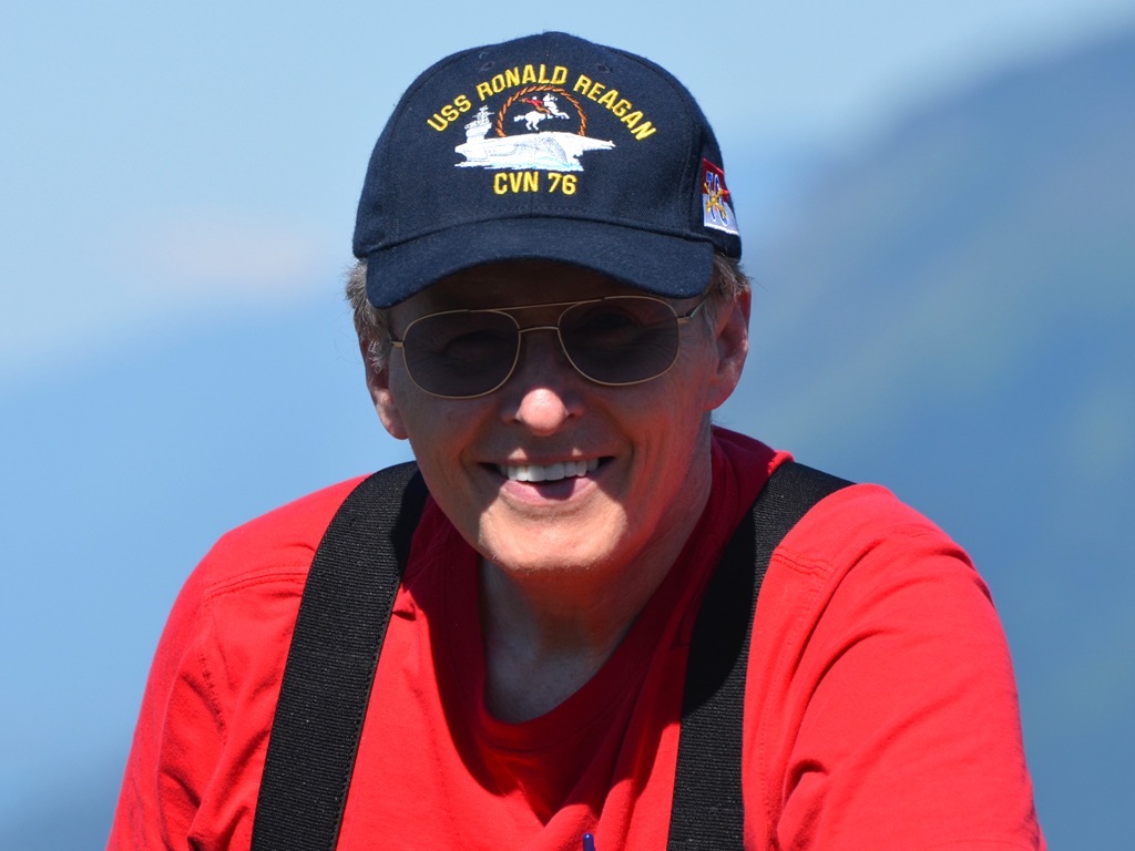
That baseball cap was a gift from my son Glenn. He was called onboard the USS Ronald Reagan, CVN 76, to work on her electronics gear, which is what he does for a living. He knew that President Reagan was the last man I voted for with a happy heart, and that I would enjoy the hat. He was right. As it turned out, I also saw President Reagan in person on the USS John F. Kennedy, CV 67. (Interesting that the digits of the hull numbers of the two ships are reversed from each other.) It was Liberty Weekend on the Fourth of July of 1986, in New York, and President Reagan set off the fireworks display that evening, while standing on the deck of my ship. I was proud to be there! So, yes, I wear that hat with a lot of pride—pride in my son, pride in President Reagan, pride in having the privilege to serve my country, and pride in my country—and happy that they named a ship after Ronald Reagan, President of the United States of America. |
||||||||||
 Dotti complains that I never stop taking her picture. I plead guilty as charged, because she is my favorite subject for my camera. I have spent over 60% of my life with her, and of all the choices I have made in life, marrying her was hands down the best one, and there is not even a close second.
After we finished with the view at Chanticleer Point, we hopped into the car and headed up to the top of Larch Mountain. The cutoff for Larch Mountain Road lies between the Chanticleer Point and Crown Point. The 700-foot basalt rock wall, has been carved into a concavity between the two points, and the Scenic Highway tracks that shape. Just before it cuts to the north towards Crown Point, Larch Mountain Road veers off to the southeast and up. It tracks across the ancient lava fields, which forces it into twists and turns across the uneven land. It cuts northeast for a time and then does a sharp turn to the southwest, as it hits the base of the ancient volcanic cone of Larch Mountain. Up and around it curves, bending back to the southeast, until it reaches the very edge of the cone on the most eastern point of its route. Turning back to the west, the road follows the volcanic cone’s edge, to the parking lot, near the volcanic plug that at one time sealed the vent from which Larch Mountain’s lava flowed. The plug, is today the highest point on the mountain and has been given the name Sherrard Point. That is where we intended to go, because there is nothing taller in that area, and from that peak, on a clear day, you can see 5 major volcanic peaks, far younger and taller than old Larch Mountain, which has been worn down by rain, and several glacier attacks, from multiple periods of glaciation, since it ceased erupting. |
||||||||||
 I just noticed something kind of strange. Our first trip up to this parking lot was the day we did our long and grueling hike down and then back up, in July of 2003. As it turned out, checking the very first photo, we parked in exactly the same parking space then as we did on this day. Now, we drove our van up in 2003, and our Honda up in 2013, but the parking space was identical.
My clearest memory of that day, was when we dragged our aching and tired bodies into this parking lot, and over to the van, and after getting Dotti situated, I opened my door and there was a large coffee mug, filled with water. It was a hot day, and the van had been closed up, and that water was very warm, hot even. But it was the best tasting water I ever drank! We had run out of water a long way down the hill and we were very parched by the time we got to the parking lot. |
||||||||||
 Now off to the left was the path that led to such an interesting trip in 2003. It heads down the mountain, and if you follow it all the way, it will empty out into the parking lot at the Multnomah Falls Lodge. But today, we would not be taking that path.
The small building on the left is an outhouse and always a welcome sight before beginning a hike. 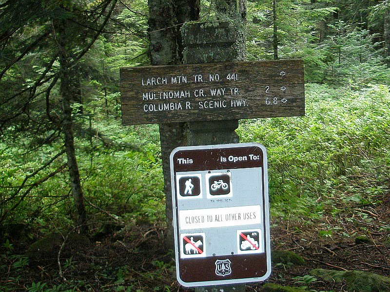 From 2007, this photo of the trail signs at this start of the trail down, shows the miles to various places. The critical one is the parking lot at the bottom, which is located on the Columbia River Scenic Highway, and it is 6.8 miles to the bottom, not to mention around a 4000-foot drop in elevation. That is exactly what we did in 2007. We went from this very point, all the way to the bottom, fools that we were. Of course, we had left the Honda at the bottom, so we would not have to climb back up to retrieve our car. So, we at least had some sense.
And one other thing, I just went back and checked, and we parked in that exact same spot in the upper parking lot in 2007 as well. That shade is important on a hot day, and I am sure that was a factor in the choice. |
||||||||||
 Joan is all set to take some flower pictures.
|
||||||||||
 I was ready to get started on the walk.
|
||||||||||
 Here are a couple of Joan’s flowers: Xerophyllum Tenax, or Common Bear Grass. I can’t say, looking at these two rounding flowers with their top projections, that the name Bear Grass would be my first choice for naming them, but there it is. They say they are closely related to lilies, and are known also squaw grass, soap grass, quip-quip, and Indian basket grass.
|
||||||||||
 I took this picture after we got back from the hike, but it shows the parking lot. Our car door is open, and Dotti is sitting down waiting for us to finish taking pictures. This was our first real walking outing in a while and Dotti was pretty tired by the end. But she came through it okay!
If you look off to the right of the car, you can see the aforementioned trailhead that heads down the mountain to Multnomah Falls. |
||||||||||
 The previous photo was taken standing at this point, but for this shot, on the right, I rotated 90° clockwise.
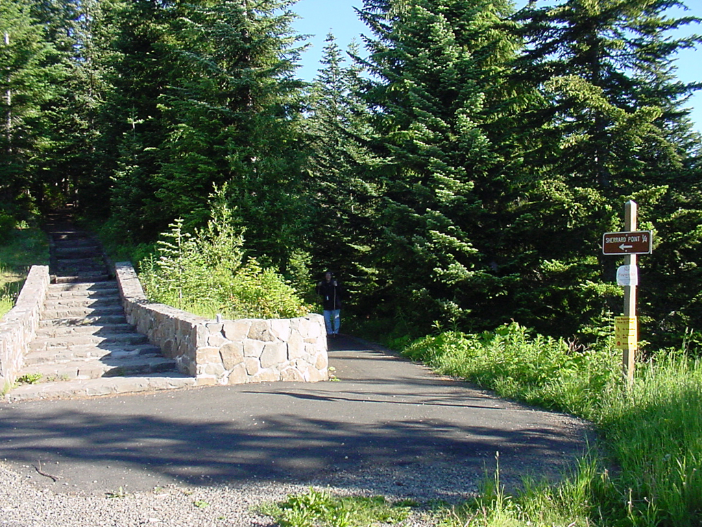 On our first trip up here, the trail was not clearly marked. There was a sign off to the right of this (see image on the left here), that pointed in the general direction of the two trails you can see, and it said, "Sherrard Point 1/4" with an arrow pointing at the two trails. Since we knew that Sherrard Point was at the summit, we assumed that we had to go up. We set off on the stairs, and found we added work with no value returned, as we reached a picnic area and then had to descend on the other side to get back down to the trail on the right, which is the correct one.
|
||||||||||
 Although this sign is not as fancy as the original one was, it clearly shows that you are supposed to take the trail to the right and it is three-tenths of a mile to the top. The red tinge you see to the plastic covering is a reflection of my red shirt.
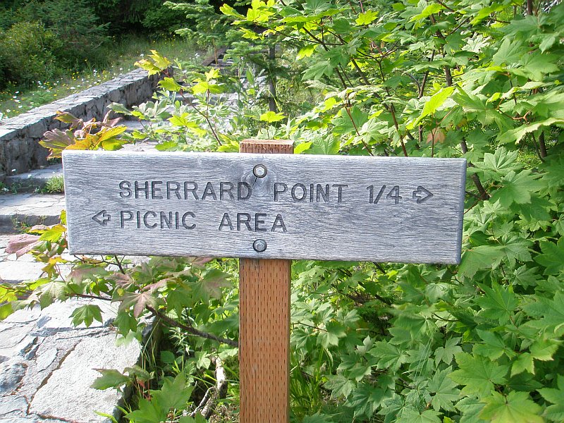
As you see in the image on the right, in 2007, they had put up a wooden sign that was clearly marked for both the picnic area and Sherrard Point. Obviously something happened to that sign in the meantime, and they are using a temporary paper sign for the time being. |
||||||||||
 Having been here in the past, we were no longer confused about which route to take, with or without a sign pointing the way. Just to the right of the sunlit bush there is the trail we needed, heading back into the shadows.
|
||||||||||
 Turning the corner, there is the trail, and we were all set to head on to Sherrard Point.
|
||||||||||
 I turned around and shot a picture of Dotti at that sunlit bush, as she was ready to begin as well.
|
||||||||||
 After walking along the gently rising trail we came up to the junction with the trail that runs up to the picnic area and then back down again.
|
||||||||||
 This photo was taken just past the junction and looking back down the trail. You can see how far up the picnic trail goes above the regular trail. Off in the distance on the left you can see Dotti and Joan walking towards the car. The reason they are heading in that direction is because I took this shot on the way back, rather than on the way up.
|
||||||||||
 As we walked up to this rock, I was reminded of a point in the book I loved as a child, The Pilgrim’s Progress, the main character, who was named Christian, came up to a wall of rock that loomed over his head and the more he walked along the more sure he was it was going to fall on him and crush him. He turned back.
We didn’t turn back, we kept going.
|
||||||||||
 Just past the rock wall and looking back, I saw a little tree growing right out of the volcanic basalt, fighting for his piece of life. He was reaching up for sunlight and driving his roots into the rock, helping to break it up. The cracks are widened by the action of the roots digging, and then water gets down into the cracks and freezes and opens the cracks even more. In time the rock is broken up and turned into soil or large sections fall down the side of the mountain, wearing it away. And as I mentioned above, this mountain has been through several periods of glaciation in the past and worn down by that as well.
Geology is fascinating. They say the Appalachian Mountains at one time were as tall as the Rocky Mountains, or the Alps. Today they are an ancient and tiny remnant of what they once were, shortened and smoothed, as time as worn them down. Even more interesting is that they are in pieces now, with part of them along the East Coast of America, and part of them over in Africa, where the two land masses were once joined together, at the time the Appalachian Mountains formed. |
||||||||||
 This shot was taken from the same spot, but looking up the side of the rock wall. Trees towering above us, stately and proud. From their tops a view of a huge panorama must be visible. We were heading to that area soon to check out that view!
|
||||||||||
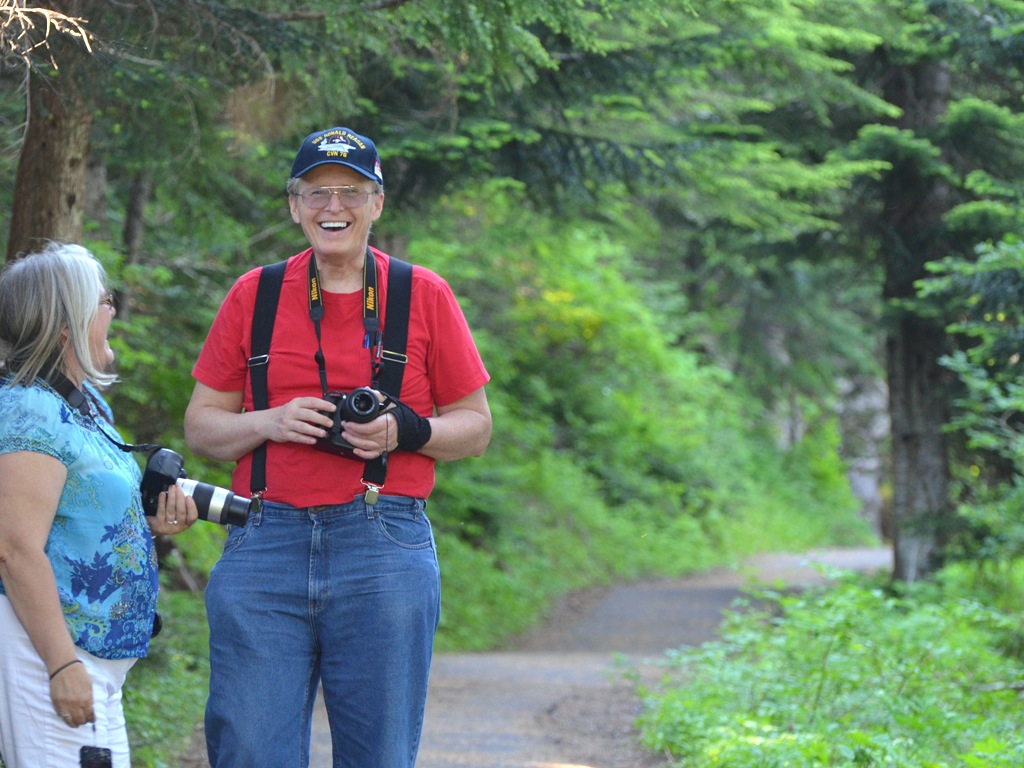 Dotti snapped this picture of Joan and I laughing on the trail. It was a very good day for a walk and spirits were up. It was the first time Dotti got out for a hike since the day she and I walked to the store a few weeks ago, on April 20th. I was not sure how she would do, but she held on and made it all the way to the top; she is no quitter!
|
||||||||||
 It was a sunny day, with lots of light for photos.
You can see the wrist brace I have been wearing for my left tendon problem. (On the link above for the walk that Dotti and I took, you will also see the ice dipping procedure spelled out that I have been using for this as well. There has been a lot of improvement so far, but there is more needed before I am back to normal for the left hand.) |
||||||||||
 On the other hand there was plenty of shade on the trail and that was good too, to keep the heat down as we walked. When you have not been out on the trails for a long time, it is good to have cool conditions and to take it easy.
But I have to say that I was hit with a great wave of nostalgic joy at being on a trail again, after so long. I really missed hiking in the Gorge! It was good to be back, very good indeed! |
||||||||||
 Two friends: Dotti and Joan. Looking back over the years, it was in September of 2001 when we first met Joan, and she has been a dear friend ever since. In addition to all the fun times we had, sharing the horrors of September 11, 2001 was something that we will never forget.
|
||||||||||
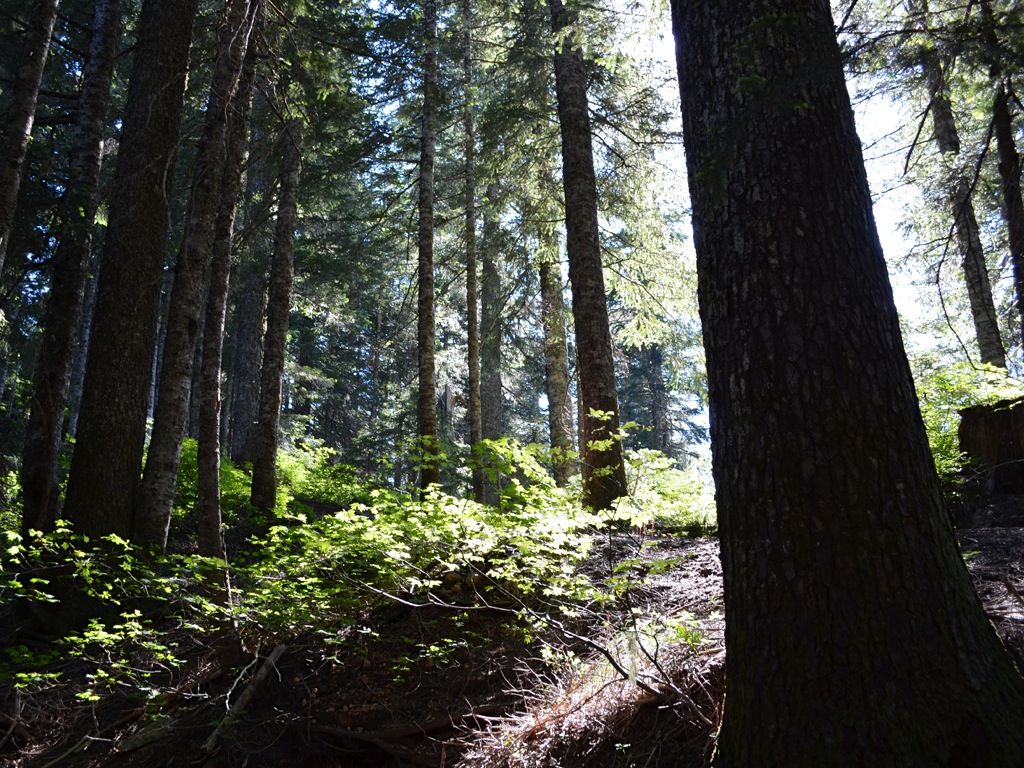
 There is something about the hiking trails in the Columbia River Gorge, that calls my name. I was hit with that feeling over and over again as we walked up to Sherrard Point. The forest, both the trees standing and the ones fallen, all join together to make it a magical place. We had sunshine, but we have hiked in the rain and it didn’t matter it was still wonderful.
Even so, there is something about the sun cutting through the trees, hitting leaves, bark, bushes, and trail, mixing with shadow and creating a scene that makes you feel glad to be alive. |
||||||||||
 As we saw with the tree growing out of the rock, here we saw another tree, fighting the conditions to hold onto life. The roots were running this way and that, passing through the air, as well as the ground, in order to hold the tree vertical, despite all that the wind and rain could do to take it down. When water is flowing it works the soil out from around the roots, leaving them exposed, but there the tree stands in spite of it all.
|
||||||||||
 I moved to place the sun behind the tree, so the shadows, as well as the sun could be seen. It was a beautiful day for a walk.
|
||||||||||
 The struggle for life eventually is lost by all things. Stumps and logs that were once vertical trees clutter the landscape, showing the great cycle of life. The tree gives back what it has taken in life as it passes into soil enriching debris. The shape it once held is disappearing over time but it lived once and new life will spring from this no longer living monarch of the mountaintop. There is a moral to this, give back what you have been given, and never give up until you can no longer stand. A thousand years from now other trees will be growing here, and their future existence is made possible by the life that has come and gone today. The sun kisses the green grass and in its own way, the grass gives thanks, converting that energy to more growth and more life.
|
||||||||||
 Up until this point things had been a gradual climb, but now we faced the stairs. The trail was going to take a sharp turn upward and these stairs were placed to make the journey easier, even though it hardly felt that way when we were on them.
|
||||||||||
 As is often the case in the woods, stairs are not what you would expect to find in a home or building. The ratio between the rise and the width of the steps is heavily weighted in favor of the width. It takes some care, paying attention where you put your feet, because the striding feels odd. Also, the architecture of the stairs is such that there is a framework of wood, which holds the earth in place, earth that forms the majority of the surface area of the stair system.
|
||||||||||
 Having gone up a few of the stairs, I took this picture, looking back down the path we had come. Off to either side, the ground is falling away, because we are approaching the summit of this ancient volcano.
|
||||||||||
 I took a video at this point of Dotti and Joan, because I wanted to capture how tired Dotti was feeling. (I didn’t include it here because it is 155 megabytes and I don’t have a quick and easy way to shrink it.) This was her first outing in a long time and we hadn’t done a hike in ever so long. But Dotti was hanging in there and kept at it all the way to the top! She was getting tired but she was not going to give up!
|
||||||||||
 Joan was just ahead of us on the stairs and in the video she mentioned it was her birthday! Happy Birthday Joan!
|
||||||||||
 The view from one volcano to another. We were nearly at the top of Larch Mountain, with just a few more stairs to go up, but first we were given this beautiful view of Mt. Hood. The rock on the left is frozen lava, part of the volcanic plug that filled the erupting tube as Larch Mountain finally ended its active days. The cone of the volcano has been worn down and left this plug as the highest point on the mountain. Contemplating the fact that one is standing on what was once melted rock, rock which had been pushed up to the surface from far below, is a bit disquieting. Not only was this ground created by the flow of molten lava, but then it was covered by glaciers, which opened up the smaller cone into something that looks closer to Mount St. Helens in shape. To walk around the cone is a six mile hike, which I hope to do before too much longer.
And then off in the distance is another volcanic mountain, much younger than Larch Mountain, and it towers over Portland and Vancouver, popping up often as you drive the streets, highways and freeways of the area, sometimes nearly filling your windshield. A minor eruption by Mt. Hood prior to the arrival of the Lewis and Clark Corps of Discovery in 1805, caused the river now known as the Sandy River to be gorged with sand and debris, causing Lewis and Clark to name it, the Quicksand River. Today, the rapidly flowing river has cleared its path and the locals shortened the name down to the Sandy River. Mt. Hood has a magma chamber below it, and it could, and no doubt will, erupt again, in its own good time. |
||||||||||
 This is looking back, generally to the west, to where the last picture was taken. It is kind of spooky thinking that this was once a bit of molten lava that hardened up to close off the vent for the volcano, to shut down the operation for the last time. Right behind us were the steps leading to the viewing platform.
|
||||||||||
 As you can see they painted the elevation of the platform on the top step, 4,056 feet above sea level. The Columbia River—which flows right beside Larch Mountain, and its beautiful Multnomah Falls at its base—is not very much above sea level, so the number represents nearly all mountain.
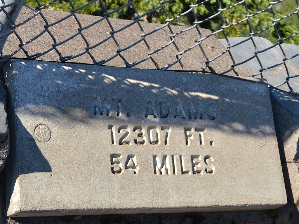
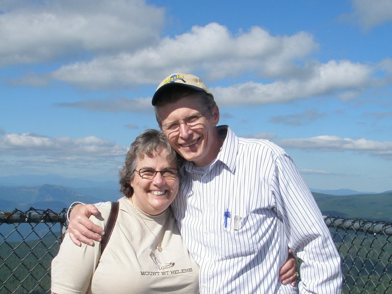 On the right you will see a photo taken of Dotti and I in 2007 on this same viewing platform, with Mt. Adams behind us. I had those nasty dentures in and I had a hard time smiling whenever I had them in. They always hurt. Fortunately, we found a solution to that.
Two weeks after that picture was taken, on August 28, 2007, five days after my 56th birthday, Dotti and I went all the way down Larch Mountain, from the parking lot at the top to the parking lot at the bottom. We were not at our best weights, but we were active still. |
||||||||||
 On the platform they have concrete plaques set up to tell you what mountain you are looking at in the distance. In this case it is Mount St. Helens. It stands 8,363 feet tall, and is 46 miles away from this spot. When you remember that Spokane, hundreds of miles away from that volcano got hit with a great deal of ash, you can imagine what would have happened to this spot if she had blow in this direction, rather than to the northeast!
When I first met Dotti, in 1974, Mount St. Helens was called “The Fuji of the Cascades”, and it was a beautiful sharply pointed mountain. It stood 9,677 feet tall then. Being new to the area at the time, I didn’t realize at first that there were two mountains visible from Portland. Mt. Hood and Mount St. Helens were both snow capped peaks that looked enough alike, I didn’t notice the difference. Today, no one would confuse the two mountains, since Mount St. Helens is flat on top, and much uglier than she was when I first saw her. Looking down at a terrain map of both Mount St. Helens and Larch Mountain, [See Larch Mountain Hike #2 for maps of Larch Moutain, and Mount St. Helens Hike, or Visit to Mount St. Helens for views of Mount St. Helens from the Northeast.] they are surprisingly similar in shape. Larch Mountain is today covered in forest so you don’t notice the caldera. |
||||||||||
 Despite its truncated height, Mount St. Helens is still over twice as tall as Larch Mountain, and its top is covered in snow. You can see the snow line, and other than for the clouds and sky, including the place we were standing, everything you see is below that line.
|
||||||||||
 Moving closer, through zooming, it is very clear how much was lost to the mountain when it erupted, when you remember that peak use to come up to a beautiful point. And it is almost certain that one day it will come up to a point again! It is a very active volcano. Dotti and I drove past Lassen Peak, in 1999, and I visited that mountain years before, and at the time I first visited it, and inspected some of its lava tube vents, it had been the most recently active volcano in the continental USA. It erupted in the early 1900s. It had also erupted twice before in the past 4,000 years. It was inactive from 4,000 years ago until about 1,200 years ago, when it erupted. And then it blew again a couple of centuries ago. So, it has been relatively quiet really.
Mount St. Helens, on the other hand, has been one busy mountain. Over the past 4,000 years she has popped off 18 times! In the past 1,000 years alone she has erupted 7 times. It seems likely that this will continue into the future. One day, people will once again look up at her pointed top, and marvel at her beauty. But that day is probably not going to happen in our lifetime. |
||||||||||
 The next mountain plaque we came to, was for Mt. Rainier, 97 miles away. This mountain is the tallest in the Cascade range, edging out Mt. Shasta (which, nudging right up against Interstate 5, was the first major volcano, I ever remember seeing, when in 1966 my folks drove me up to my school for 9th grade), which is also over 14,000 feet tall. Mt. Rainier is really most often associated with Seattle. But, it is far enough away from Seattle, so that it appears about the same size as Mt. Hood does to Portland, even though it is about 3,000 feet taller than Mt. Hood. The area around Mt. Rainier is densely populated, so it would probably make a mess if it blew.
Unfortunately, considering the population density surrounding it, this is the only one of the Cascade volcanoes that can come close to Mount St. Helens for its activity over the past 4,000 years. Mt. Rainier has erupted 11 times, and over the past 3,000 years, Mount St. Helens has only erupted 3 more times than Mt. Rainier. Fortunately, over the last 2,000 years, Mt. Rainier and Lassen Peak have erupted exactly the same number of times! Hopefully, it will be some time before Mt. Rainier picks up that intensity once more. |
||||||||||
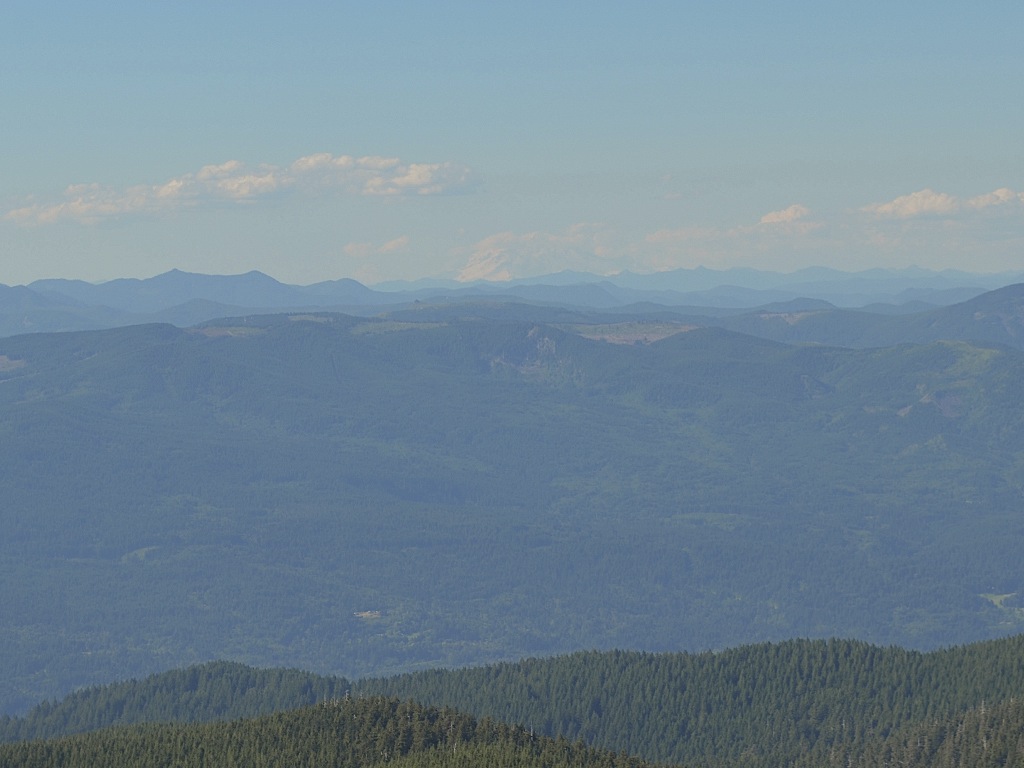 Looking off those 97 miles, you can just barely see Mt. Rainier, with clouds all around her.
|
||||||||||
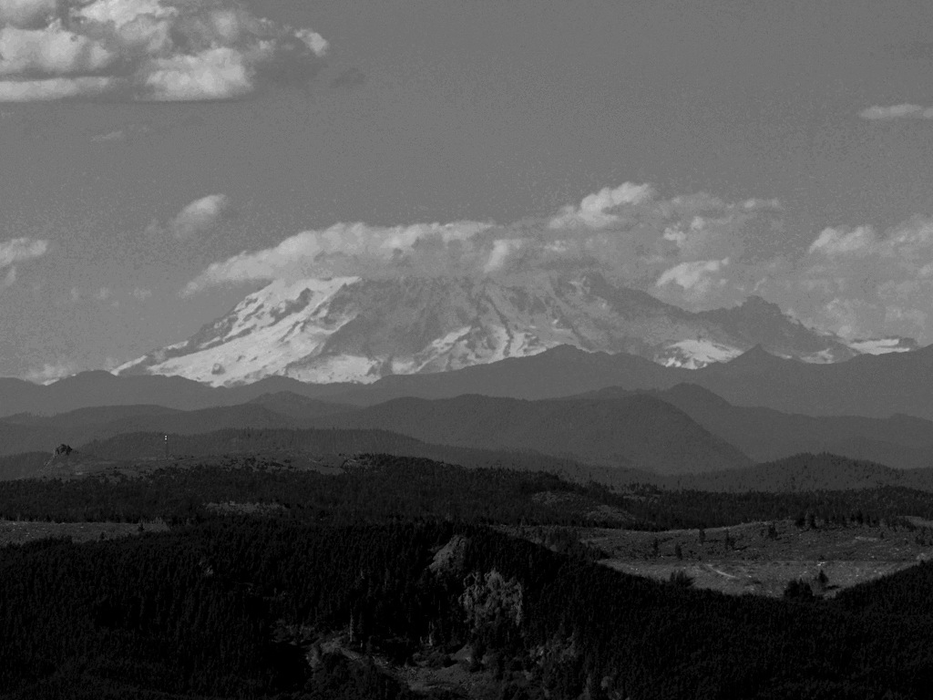 Using a zoom, we could bring Mt. Rainier closer, but it destroyed the color of the scene, so I converted the image to black and white so you could see the shape of the mountain, and its snow and cloud covering.
|
||||||||||
 Over in the far left corner of the platform, was the plaque for Mt. Adams, the 12,307-foot volcano, which, even though it is only 54 miles away, is not easy to get to. It doesn’t have the road system access and trails commonly hiked that the other tall volcanos do. So, even though it is taller than Mt. Hood, it is isolated and not a point of visitation by all that many each year.
|
||||||||||
 When driving west from the other end of the Columbia River Gorge, on a clear day Mt. Adams is the first volcanic peak you may spot. I have been fooled in the past, thinking I was seeing Mt. Hood off in the distance, when it was Mt. Adams. It is a beautiful mountain!
|
||||||||||
 From this vantage point, Mt. Adams does not come to a point, but is built like a mini-mountain range all its own. But with the snow covering, it still is an impressive sight!
|
||||||||||
 Mt. Adams has only erupted twice over the past 4,000 years and it has been about 1,000 years since its last one. But there are various points of uplift, indicating that older eruptions must have happened, and its lava flows have worked their way all around the peak. It has been a major player in the past. And is always the case with these newer volcanos, they will almost certainly be coming to life again.
|
||||||||||
 Now moving to the far right corner of the platform, from the stairs, we come to the plaque for the 11,235-foot Mt. Hood, only 22 miles away. All the time we were away from Vancouver, I missed seeing Mt. Hood. It is a beautiful part of the Portland and Vancouver area, and not easily given up!
|
||||||||||
 Using a standard lens, you get the feel for the rolling nature of the terrain, and can see the lush forest growth, calling this volcanic field home. The area around Mount St. Helens look just like this before she blew, and knocked everything flat.
|
||||||||||
 Mt. Hood, like Mt. Rainier, has a troubling nearness to a dense population center. Half of all the people who live in the state of Oregon, live in the greater Portland metropolitan area. If Mt. Hood fired off an explosion the way St. Helens did, directed straight at Portland, it would be very ugly indeed! Fortunately, Mt. Hood, just like Lassen Peak, has only erupted 3 times over the last 4,000 years. However, two of those eruptions came during the last 200 years. Is it merely coincidence, or is this a warning that more is to come? Portland has grown so attached to Mt. Hood, that it is hard to fear her, but she vents steam and has a magma chamber sitting below her. At some point, she will erupt again. Who knows when, our how violently?
|
||||||||||
 The clouds are casting their shadows over the snow and glacier covered terrain of Mt. Hood. Will this lovely mountain, with its sharply pointed peak, as viewed from this angle, one day look like Mount St. Helens does today? It may, but I hope I don’t see it. That could easily cost way too many lives!
|
||||||||||
 When you move in close to Mt. Hood, you realize just how rugged its terrain really is. People die up their quite often, but that doesn’t stop more people from going back to hike and climb this beauty.
|
||||||||||
 And finally coming to the final plaque on the platform, we come to the Mt. Jefferson information, 10,497 feet tall, and 82 miles away. This mountain is named for my favorite president of the United States. There is no close second in my opinion. He was brilliant beyond belief, and he was instrumental in helping to lay the foundation upon which this country was built and grew to greatness upon. Today, all that has been undermined, but it doesn’t take away the genius this man invested into our country. He is my greatest American hero.
And it should not be forgotten that it was Thomas Jefferson who took the Louisiana Purchase, created the Lewis and Clark Corps of Discovery and kicked off the migration that ran the territory of the USA from coast to coast for the first time. |
||||||||||
 Mt. Jefferson looks distant and her grandeur is lost in the haze, but there she stands, bearing the name of my hero, and reminding us of what amazing things can happen when brilliance is allowed to work for good, rather than being crushed by tyranny.
As a volcano, Mt. Jefferson has been quiet for over 4,000 years. That may be symbolic of what is to come to a land that has rejected such brilliance, in favor of that which, even being most generous, is a proven failure, without exception. Mr. Jefferson deserved better. At this point we headed back down to the parking lot, retracing our steps. When we reached the parking lot, Dotti got into the car and rested, and she remained in the car for the rest of the visit to the area. She was very tired, and this was a major outing for her first time out in so long. But she made it to the top! We drove back down to the Scenic Columbia Gorge Highway, and turned east. Soon we found ourselves coming to Crown Point, where Vista House has sat proudly since 1918. |
||||||||||
 They closed up at 6 pm and we arrived just after that, so we couldn’t go inside, or get up to the viewing balconies on the second story. But we still could take in the wonderful view of the Gorge!
|
||||||||||
 Dotti was pretty much wiped out by the hike, and rested in the car, and playing on her smart phone. If you look really close in the right side review mirror you might see her face.
Beyond the car you can see the Columbia Scenic Highway curving sharply around beside Vista House. We came from the upper right corner of this picture and went entirely around the Vista House, and came back to this spot to park. When we finished here we continued to the right on the highway and quickly dropped down to the level of the Columbia River where we could see some waterfalls. |
||||||||||
 Here’s Joan getting into the car, and I shot this one out of order, but I put it with the other car shot. This is a very busy spot for tourists. First of all, any major shot of the Columbia River Gorge seems to include Crown Point and the Vista House as part of it. (See the shots above we took at Chanticleer Point.) And then when you stop here, you are treated to an incredible view of the river and the Gorge.
|
||||||||||
 This is looking east, and in the foreground you see the Columbia Scenic Highway as it is leaving Crown Point already having dropped below the level of Vista House by quite a number of feet. Beyond that, there is a large drop as you next see Interstate 84 running along surrounded by a thick stand of trees. And then the mighty Columbia River takes center stage.
The Columbia River is the largest river in the Pacific Northwest and dumpes more water into the Pacific Ocean than any other river in either North or South America. It runs along for 1,214 miles, from its source at Columbia Lake in Canada, beginning at an elevation of 2,650 feet, and flows through 4 mountain ranges—the Rockies, Selkirks, Cascades and coastal mountains—as it drains 258,000 square miles. Its largest tributary, the Snake River, starts in Yellowstone Park in Wyoming, cutting some incredibly beautiful canyons in basalt strata that leave one breathless. (If the canyon under the bridge, which supports the road leaving the freeway heading to Twin Falls, Idaho, doesn’t make your jaw drop you have to be dead.) Even the Spokane River drains into the Columbia, as does the Clark Fork River, which was blocked by a glacier and created Lake Missoula, and that supplied the water for the Bretz Floods. British Columbia, Montana, Idaho, Washington, Wyoming, Oregon, even Utah and Nevada, add water to the Columbia River. When you look at the Columbia, you are looking at water that has come from a lot of divergent places! Off to the right, is the start of Larch Mountain, and just around the corner of that basalt protrusion into the Gorge is the beautiful Multnomah Falls. On the left in the distance there is a dark rising chuck of basalt, right next to the river, and that is Beacon Rock. And the rising basalt to the left of Beacon Rock, is Hamilton Mountain. So many happy memories for Dotti and I are right before us in this picture. |
||||||||||
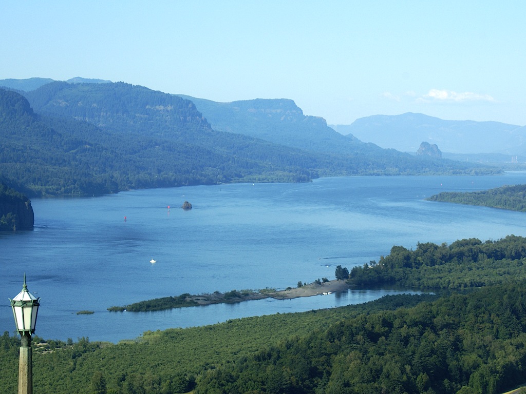 Zooming in a bit on the Columbia River and Beacon Rock and Hamilton Mountain.
|
||||||||||
 And dead center, zooming in we see the Bonneville Dam. We see that every time we go to the Pool of Winds.
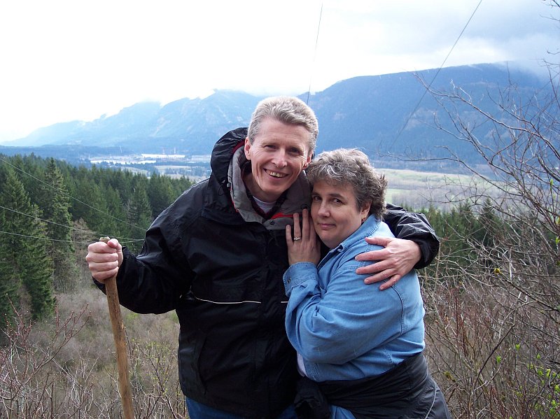 This picture of Dotti and I, is one of my favorites, and it was taken by our good friend Tom who, along with his lovely wife Barb, made the Pool of Winds hike with us. Off in the distance you can see the Bonneville Dam, and the power lines running right over our heads were hauling power from that dam. A whole section of a mountainside gave way, and slid out into the the path of the Columbia River, and formed a natural dam, and when the river finally breached the natural dam, it had moved the course of the river south by a mile! It also made for a very good place to put a dam, that would require less length and therefore less cost.
Anytime you hike the trails in the Columbia River Gorge, you almost always see large rock slides that were caused by a portion of the basalt walls giving way. But the Bonneville Slide was a huge one! |
||||||||||
 Zooming in on Beacon Rock. I remember when Dotti and I first went to the top of that, and the most striking memory I have is of the huge amount of wind that was up there, with nothing to block it. During the walk up, it was not that noticeable, but at the very top it was very strong.
Over on the coast you will see rocks that are similar to Beacon Rock, in their origins. Just like Sherrard Point, this is a volcanic plug, which blocked the vent tube of an ancient volcano. Plugs are always made of harder material than the rest of the volcanic mound or mountain. In this case, the actual volcano was located at river level, in the path of the powerful Bretz Floods, which ripped through the Gorge near the end of the last Ice Age. The wall of water, thousands of feet deep, hit the mound surrounding the Beacon Rock plug and eroded it away completely, leaving the hard plug to sand alone, like a tower. |
||||||||||
 The Columbia River is very popular with water enthusiasts, you can see several boats on the water. Because of the nearly constant wind in the Columbia River Gorge, in certain areas you see dozens of wind surfers.
The water is cold, so you often see them wearing wet suits to stay warm, even on the hottest days. Many rivers and streams feed into the Columbia River, including the Deschutes River, which we went white water rafting on in 2008. The air temperature that day was over 90° F, and I was very cold, just getting splashed by the river water. When Dotti jumped into the river for a quick swim, she was shocked at how cold it was! She was frightened that she might not make it out without help. |
||||||||||
 Seeing barges on the Columbia River is very common. The dams along the river have lock systems so ships can get past them.
|
||||||||||
 Here is Joan, shooting a picture. To the right you see a coin operated telescope, where you can view various things in the Gorge up close.
|
||||||||||
 Turning to look west, past one of the old light fixtures at Vista House, you see the meandering of the Columbia River as it works its way towards Portland and Vancouver. Off in the distance you can just see the Glenn L. Jackson Bridge, which carries Interstate 205 over the river. We crossed that bridge coming to the Gorge and when we were done, we crossed it again to get back home.
The Columbia River, throughout the entire length of the Gorge defines the border between Oregon and Washington states. We were standing on the Oregon side and everything on the other side of the river is in Washington. |
||||||||||
 Here is a closeup of birthday Joan. Happy birthday!
|
||||||||||
 We left Crown Point and continued east on the Columbia Scenic Highway. Our next stop was Latourell Falls, with its beautiful 249-foot drop.
Latourell Falls, named for Joseph Latourell, postmaster when a post office was established in the area in 1876, less than 20 years after Oregon became a state in 1859.
We left Crown Point and continued east on the Columbia Scenic Highway. Our next stop was Latourell Falls, with its beautiful 249-foot drop.
Latourell Falls, named for Joseph Latourell, postmaster when a post office was established in the area in 1876, less than 20 years after Oregon became a state in 1859.
It was a beautiful day! |
||||||||||
 My feet were pulling me down that trail that runs towards the falls. I love hiking in the Gorge and it is tough to just come to a trailhead and look without walking. I didn’t realize how much I missed hiking these trails, until we hit the parking lot on top of Larch Mountain, and started on the trail up to Sherrard point. Suddenly it all came back to me.
And here I was knowing exactly what J. R. R. Tolkien meant when he put these words in Bilbo Baggins’ mouth: “It’s a dangerous business going out of your door. You step into the Road, and if you don’t keep your feet, there is no knowing where you might be swept off to.” In the Lord of the Rings books the roads were not much more than one of these hiking trails, and once your feet are on one, there is no telling where it will take you. Keeping your feet is not easy! |
||||||||||
 This is the viewing platform area, with a great design for the rock walls, including the grating. Even the highway bridge is artistically done. The hand rails you can see, are for the stairs, leading down to the trail in the previous photo.
|
||||||||||
 And here is Joan posing behind the end support pillar for the highway bridge. It was getting later, and the sun was cutting a sharper angle, throwing longer shadows, and highlighting the green which surrounded us everywhere.
The evergreen forest runs all over the Cascade landscape, but the Gorge has its share of deciduous trees and bushes. So, the time of year you come will cause the scenery to change drastically. What is a great view in autumn or winter, through the bare branches of trees and shrubs, will be just a wall of green in the summer. The same hike, on the same trail, is never, ever, the same hike on the same trail; because the trail changes. Even the same day, at different times of day, the trail will change. It is like a magical wonderland that is forever changing. |
||||||||||
 I did “lose my feet” for a moment and I set off on the trail. It was seriously hard to stop; I wanted to keep going.
|
||||||||||
 I got down to the corner and there it was, more trail! I wanted to keep walking, but alas, it was not possible. The moss covering the volcanic rocks, and the green leaves wrapping themselves around the trail in an embrace were whispering to me, asking me to come on. I had to dig down deep to control my feet at last, and turn around. Sigh.
|
||||||||||
 Looking back up the trail to the viewing platform I knew I had to head back. But it would be here another day!
|
||||||||||
 I crossed the road and worked down a bit past the railing to look west, at the bridge that we had just driven across. Concrete, shaped in arches, supporting 3 spans, with decretive posts, covered with patches of moss, reaches out for 310 feet, to cross the Latourell Creek, and has done so since 1914, nearly 100 years! The road it supports is 17 feet wide, with two sidewalks making it safe for walkers to cross, and increasing the width to 25 feet. The road is nearly 100 feet above the creek.
The trees, reaching out their branches, almost seem to be sentient, watching over the bridge. Life abounds in the area around this creek; the rock walls of the canyon are invisible, covered completely with greenery. |
||||||||||
 Moving back to the road, Joan is nearly on the other end of the bridge, and the trees are nearly forming a tunnel for it to pass through. Green vegetation, blue skies and bright sunlight, painting a wonderful scene for us to enjoy.
|
||||||||||
 Looking east from the bridge, there is our car on this end of the parking lot, and my lovely wife was patiently sitting in the front seat waiting for us wanders to return. Going up to Sherrard Point had used up all her physical resources and she was content to rest.
|
||||||||||
 After walking the length of the bridge, I headed back to the car, and there was my lovely Dotti, smiling brightly for me! She had her smart phone with her and that helped keep her company.
It was time to move on to our last sight seeing stop. |
||||||||||
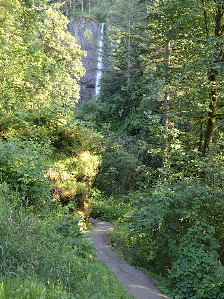
 Horsetail Falls is located at the trailhead of the start of the Triple Falls Hike, which we did in 1997, again in 2003, and then once more in 2006.
It is also a great spot for a quick stop just to look at. |
||||||||||
 Here is Joan, lining up a shot on the Falls. Not visible here, there were also some people swimming in the drop pool of the falls.
|
||||||||||
 And here is the falls itself. You can see where it got its name, as it does look a bit like a horse’s tail, as it cascades down from bright sunlight, into the shaded drop pool.
|
||||||||||
 Guess what year these steps were put in place? Okay, you don’t have to guess, it says 1985 right there in the wall. These steps lead down to the drop pool at the base of the falls.
|
||||||||||
 This is looking back up the stairs after going down. One of the things that is most easy to come by in the Gorge is basalt rock. The basalt lava cools in such a way that there are distinct clumps of solid stone, held together poorly, to form the layers and vertical walls of the Columbia River Gorge. Everywhere you look, you find loose basalt stones lying on the ground. If there are none today, just wait, because some new ones will fall out of the walls soon. It makes a great building material for stone walls and houses, however.
|
||||||||||
 Joan is now near the drop pool of Horsetail Falls and lining up a shot. On a hot windy day, moving over to the right, and standing at the edge of the pool, you will get a wonderful cool mist from the falls that will take the nasty heat right out of you.
|
||||||||||
 And this is what Joan had been looking at. It is funny how water interacts with light. The very same water that looks so dark in the pool, looks bright white as it falls down its rock slide.
|
||||||||||
 Just during the time we had been there, you can see that upper part of the falls is starting to get covered in shadow. The sun was moving quickly towards the horizon.
|
||||||||||
 Across the highway, there was Dotti, waiting in the car patiently for us. I was very happy to see her get out and do a hike! It has been a long time, and I think she did really well. My hope is that we will start doing regular hikes again now, and she will work up to some serious hiking before you know it. She has a good strong heart, and when she gets in even moderately good shape she has more endurance than I do.
This was a great day for me. I really enjoyed having Joan’s company as we toured some of the scenic beauty of the Gorge, and I was excited to see Dotti get out on the trail again. And I simply loved walking along the hiking trail once more. There is nothing else like it! |
||||||||||
| [ Home ] [ DWLZ ] [ Message Board ] [ Restaurants ] [ Order Cookbooks ] [ Dotti's Newsletter ] [ Support Dotti ] [ FAQs ] [ Email Dotti ] [ Email Al ] |