DAWSON CREEK PARK
MARCH 29, 2007
The Coon Family Hiking Club
Official 2007 Hike #2
2.0 miles - 1 hours 12 minutes
|
Click to view an earlier visit to this park in October 26, 2001
The seven lakes of Dawson Creek park are laid out generally in the shape of a 'V'. The junction of the two legs is to the south. The shorter leg of the 'V' runs from the junction to the northwest, while the longer leg runs off to the north east. |
|||||
 Unlike most of our hikes, this was an urban walk. We parked our car in the Costco parking lot (Point A on the map above), a paved area of ground where grass was growing and little animals were playing only a short time ago. This is a very new Costco and I watched them build it. It went from vacant lot to servicing customers in just a few short months. I was amazed at how fast it went up.
 The sky was very blue, and even in town we have pine trees meeting the eye. Dotti was not feeling really energetic yet, but we were just getting started. This sidewalk didn't exist when I used to take lunchtime walks on the road behind where Dotti is standing, and I used to look through the windows you can see in the building in the background quite often, to check on the progress they were making on building Costco.
 I have my sunglasses and ball cap to keep the sun at bay, and my jacket on because it was about 50 °, which is a bit cool for me. Although the temperature would hit 69 before the day was over, it wouldn't clear 60 before our walk was over. So, the jacket was comfortable for the entire walk. The extra pounds that I am carrying are visible here, and my program to fix is overdue. (However, it is good that it has at least begun finally.)
 I have seen some big changes on Airport Road over the years. This hill used to be two lanes, and no sidewalks. When I was walking up the hill on the other side of the road, I had to make a choice between walking on the road and keeping an eye out for cars, or walking on a dirt path that was not very well defined, and definitely wet and muddy on a rainy day. The path ran several feet away from the road, and there was a tall tree, about two-thirds up the way up the hill, that marked one of my mile markers on my walking route. Now look at it. It is a wide road with new sidewalks on both sides, and even lined with a decretive concrete wall. It is interesting to see how moving a Costco in will change the area surrounding it.
 This is Dawson Creek, as it is leaving the park. The only time I saw this running really heavy was when they were pumping the lakes dry so they could do maintenance on the plumbing in them, that circulates the water in them. For a few days this was a very full creek. They have put in some plants, covered with netting to keep animals from eating them I assume, and when they grow they will look nice and probably provide some erosion control for this area of the stream.
 (Point B on the map.) I have spent many hours in the building behind me in this picture. I have been called in on Saturdays to work their implanters, as well as spent many of my workdays there. I am smiling, because I don't have to go to work there today.
  And Dotti has Costco behind her.
  I have no idea how many times I have walked past this very spot. I have walked in freezing cold, and heavy rains. I have sweltered in the summer heat, and had the wind whipping my coat against my back, but I have never seen it look so lovely as it does right here with my Dotti being a part of it. Thirty-two and a half years ago, when I first laid eyes on this beautiful woman who was walking up the gangway of my ship that was tied up at Swan Island, my heart did a funny thing inside of me. She still has the effect on me.
 These pines form a strip that runs along for a short ways. It is as if a giant had decided to do a bit of landscaping beside his sidewalk and added a few trees to look down upon as he walked by on his way to work each morning. They run between our path and the building on the other side of them. I have always been glad that they are there when I walk along this part of the trail.
 "Jack Frost" is giving way to "Jack in the Green" as the bare branches of some trees are reaching into the sky, while other trees are loaded with spring flowers. Many bushes are brown and leafless still but things are in the midst of change and, spring is in the air. What a glorious day to be in love and to walking with my girl!
 On the side of the path it looks like the landscaping giant has been pushing over trees. Several of them were lying on their sides with clumps of earth grasp by the roots in a death grip. Apparently these trees did not fit into the plans of the Dawson Creek Park caretakers.
 These trees are always in a hurry, as far as trees can ever be "hasty." They explode with color and beauty every spring, and usually they do so well ahead of everything else. They also are the first to lose their leaves in the fall. I like that. It is fun to see spring approaching and fall on the way in, even when the rest of nature hasn't gotten the message yet.
 (Point C on the map.) The gentle giants of the forest tower above us as we pass by. Their heads are so high up that we look like ants to them as we pass by. What is it that they are saying to each other when their branches sway? I have heard the wind blow through their needled arms many times, and sometimes it moves strong enough to tear some of those branches off, to leave them on the path beneath my feet. But these tolerant evergreen towers have never objected to my walking amongst their feet on windy days, and listening in.
 Looking behind us there are two dogs on leashes, held by an arm whose body is hidden behind a tree. This park is a very popular walking spot. On my lunchtime walks I often passed by "regulars" who came out for walks nearly every day. From the first time I discovered this park in 1995, I have always enjoyed the way it was laid out and how well they kept it up. There was one older gentleman, who had a gray beard, and whom I often passed on my early morning walks. He had a little Scottish Terrier on a leash, and it was feisty! I don't know what he thought he would be able to do with me if got a hold of me, but he was testing the strength of his leash as he worked out his vocal cords, straining to reach me. He was so small that it was merely cute and not in the least bit frightening. I could see that the man really was fond of his dog and its antics.
 Looking up at these titans puts things in perspective. We little mammals walking by their ankles aren't so big after all.
 Continuing on past the trees, Dotti is still in their shadow. They have reached out to give us one last parting touch, to send us on our way. We would not be coming back this way, and so, at least for now, this was goodbye.
 Off to our right, it looked as if our landscaping giant had taken his coffee cup and carved out a trench in the ground. The only time I have seen this running with water was when the pumps were running to drain the lakes for maintenance. The water was lifted from the lakes and simply deposited here, to run into Dawson Creek, which empties into Rock Creek, and then into the Tualatin River, which flows into the Willamette River just in time to make a run past downtown Portland on its way to the Columbia River and on to the Pacific Ocean. Instead of running a straight 6 miles into the mouth of the Willamette River, the water nearly makes a full circle around the city of Portland before reaching that point.
If we should get enough rain to fill the lakes to where they would overflow, this trench is the route the water would take. Across this beautiful lake, which is reflecting the blue sky so nicely, is a building that has never been occupied and has stood vacant for years. (Someone had to have "taken a bath" on that project.) However, this dark story is about to have a happy ending, because this building has been chosen as the site of the new Hillsboro Public Library. There are geese swimming on the lake, and it is a beautiful day.  (Point D on the map.) Across this beautiful lake, which is reflecting the blue sky so nicely, is a building that has never been occupied and has stood vacant for years. (Someone had to have "taken a bath" on that project.) However, this dark story is about to have a happy ending, because this building has been chosen as the site of the new Hillsboro Public Library. There are geese swimming on the lake, and it is a beautiful day.
 In March, almost exactly two years ago I took this picture of this same lake. The pumps had been hard at work and the water level was taken down to almost nothing. The tree is no longer dipping its feet into the water, and the plumbing that moves the liquid around is not even touching the water. On the hills of Missoula, Montana there are lines marking the lake shorelines that Lake Missoula had during the last ice age. To look at the city today, it is hard to believe that the valley was ever filled with water like this lake was, but there are the lines to prove it, just like the line shows where the water was sitting before they drained the lake. Such physical history markers are very helpful in reconstructing the past which we were not around to witness for ourselves.
 It really changes the way things look with the water level lowered so drastically. But even then this park was a beautiful place to visit.
 However, when you bring back the water, throw in some sunshine and some geese, things really look great! For years I had walked past the building in the background and wondered how the fact that it stood empty for so long after being built was impacting whomever built it. I wondered who would finally use the building when they found a tenant, but the idea of it becoming the public library had not crossed my mind. It is a very large building and I hope they fill it with good books.
 Dotti always likes little animals. I don't know if you ever saw the great 1960 Disney movie Swift Family Robinson, but Dotti reminds me of the delightful character Francis Robinson played by Kevin Corcoran. She loves animals! When we are out on the hiking trail she is eager to have fun with any critters we come across. Here she is enjoying the geese who have made this lake their temporary home.
 Looking back the way we came. The dry overflow ditch feeds into the actual Dawson Creek, which in turn flows past the tall pines we were enjoying just a few minutes before. If the camera were rotated 90° to the right, the spot where Dotti was standing in the last picture and lake she was admiring would be in full view.
 I think that this is my favorite shot of the day. Looking from point E on the map to the northeast we see the southeastern most lake of the seven. This lake is easily the widest of all the lakes, but it is shorter than the one we just looked at (beside the new library building). It looks beautiful with the blue sky and trees reflecting from its surface. The leaveless trees are actually a plus in the picture, because the view is nearly completely unobstructed, and the white tree trunks provide enough contrast to still add beauty to the scene.
 If you take away the water and the blue skies, what do you have? It is quite a change! However, once you get used to the change, the area still has its pretty side to it. The drastically lowered water level has still left enough water to send us an upside down view of the trees and the gray sky. It is really interesting to see the amount of green that is present across the muddy ground that was underwater only a short time ago, and soon would be again. If the sun were out and highlighting the grass, trees and sky, this scene would be much closer to the previous one.
 After just a slight turn of the camera to the north, we see a walker on the path that we would be taking shortly (the path not the walker
  In this photo we are looking due east, at the southern shore of the lake. There is another walker on the path the runs along the far shore. We would not be walking on that part of the path today ourselves.
 March 18, 2005 found this nearly same view looking quite different. The camera is turned just a bit farther south from the position it held in the previous picture, and you can see the overflow route under the bridge that leads to the trench we saw earlier. We can also see the pipe, whose opening is boxed that has screening to filter the water that will be pumped through it. Once the water is pulled into this pipe, it is sent all the way up to the farthest lake at the northeast tip of the 'V'. There it will normally be pumped up into the air by the fountain that first drew me to this park back in 1995 when I spied it from across the street. The cycle moves the water up to the top lake, and gravity pulls it back down to this lake, along the pretty little streams that were laid out for its travel.
 The designers created a very nice setting for people to enjoy this park. There are benches and lights all along the path. On warm summer days, couples will often enjoy these benches as they share there happy moments with each other. These benches also marked the half-mile point from where I used to start my walks.
 If you look at the map you will notice that this lake has the shape of a ladies one-piece swimsuit. Here we are looking east across the "waist" of the swimsuit.
 This is the upper right shoulder of the "swimsuit". There is a grating and some protected plumbing that lies beneath it. Also, we can see some geese enjoying the water, as they take a swim.
 In another view from 2005, we again see the grating, but we also see the lake bottom. The missing water has left a setting that seems to go better with a gray sky than it might with a blue one. I remember walking by the empty lakes and hoping that they would be soon filled again. Even when they started to fill them, it took some time, and it was when we got a very strong rain shower that actually filled them all the way to the top where they belong.
 Here we are standing at the "right shoulder", and looking southeast diagonally across the "swimsuit". The scene takes on a different flavor at every angle from which we view it. Here it seems more closed in, because of the surrounding trees and bushes.
 Although taken from nearly the same point, the 2005 view is quite different. I was standing closer to the lake, or the mud that had been at the bottom of the lake, and so the surrounding vegetation was not visible. Also, we can see the metal grating in this view, and it was blocked by the bank in the last photo. It is clear to see that the lake is normally shallower here on the "right shoulder" than it is for the rest of the lake.
 This is the bridge that crosses the connecting stream between the lower lake that we have been viewing and the next lake up in the chain. The trees are still bare, but that will not be true much longer.
 The bridge from the previous photo is on the right, and another bridge takes center stage. This bridge goes right across the two segments of this lake. Notice how close the water is to the bottom of the bridge.
 After moving along just a bit farther we can now see both bridges very clearly. The old water line is marked by the grass on the left, and it appears to be down 4 to 8 inches from normal.
 Looking at the right hand bridge back in March of 2005, with most of the water gone. For me it was a very strange sight, because I had walked past these lakes and bridges many, many times in the past.
 Moving back to the present again, this is the stream that feeds into the second level lake, with the two bridges we were looking at. The have placed benches along this area and their placement has had changing circumstances for those who chose to sit there. For years the benches that are off in the distance, and facing away from us, were fairly secluded. There were trees and bushes growing thickly down by the water. But all of that has been cut back and now the benches are standing in the open, and sadly, at least for now, the water isn't even flowing by any longer. It has been a favorite location for couples to sit, but today the benches sit empty.
 Looking left we see a tree waiting for its leaves. Just over the hill behind it lies the short leg of the 'V' and the new library building.
 From Point F on the map, we are looking forward along the trail is the lake that is third from the top of this leg of the 'V'. The trees here are already moving along towards the spring celebration of life.
 "Oh bees! Oh Bees! Come and get it!" The tree branches are saturated with pretty flowers and after winter's bare branches have greeted our eyes for so long these pink beauties are very welcome.
 Speaking of Beauties... I called to Dotti and she turned around so I could catch this picture of her. She was not feeling her best this day but she came out for a walk anyway and I really enjoyed her company!
 "Here I am!" Dotti says with arms spread wide. She is so much fun to have on these hikes. She is one of kind!
 Two years earlier the lake was drained down and looking far less enticing, but the trees were just as brightly colored with spring flowers.
 Today the lake is filled and the sun is shining. Everything is filled with life and beauty!
 We will shortly be going under the bridge in the background, but first we have to take a little detour.  Here is my lovely Dotti! We are at the bridge that crosses the stream and leads from Point F to Point G on the map. A little later in the year this spot is covered in shade from the branches above loaded with leaves. But the branches are naked today and the sun is able to come down and kiss this lovely face.
 Dotti and I swapped places and she took this one of me.  This babbling brook captured my fancy the first time I came to this park in 1995. I stood on the same bridge as I stood taking this picture and watched the water flow by and listened to it cheerful noise. What brook? What water? What noise? It looks pretty dead here doesn't it? For some reason they have the circulation pump shut off and the water is not flowing from the upper lake down through the system.

 These pictures were taken from Point G on the map.
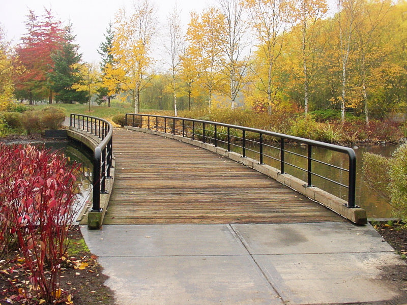
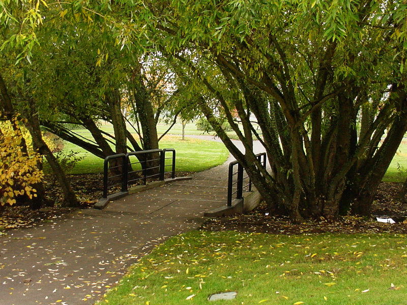
The light that was able to shine on Dotti's lovely face was made possible by the lack of leaves on the trees you see here. But as you can tell in the picture I took in 2001, when spring finishes working her magic and summer has built into a paradise for plant life, these trees are loaded with green leaves and produce a lot of shade. The bridge stands cool and inviting in the summer heat, and even when autumn starts to chill the air a bit, things are still nice under these trees. These pictures were taken from Point G on the map.
The light that was able to shine on Dotti's lovely face was made possible by the lack of leaves on the trees you see here. But as you can tell in the picture I took in 2001, when spring finishes working her magic and summer has built into a paradise for plant life, these trees are loaded with green leaves and produce a lot of shade. The bridge stands cool and inviting in the summer heat, and even when autumn starts to chill the air a bit, things are still nice under these trees.
 Now we are over the bridge and almost ready to start moving from Point G on the map towards the underpass that runs beneath Dawson Creek Drive. Dotti is hanging on with a smile.
 This path runs along the eastern edge of this leg of the 'V'. We didn't walk on this part of the path today. 
The third lake from the top of the 'V' viewed from the path to the east of it.

The same spot viewed in 2005 when the lakes were drained. 
Turning the camera to the right a bit.

Once again, how it looked in 2005. 
And back to normal, with water filling the lake in 2007.

Moving to the bridge under Dawson Creek Drive. 
Dotti is almost all the way out the other side, just as I am heading under the bridge.

Here is the second lake from the top as I am coming out from under the bridge. 


 (Point H on the map.)


 (Point I on the map.)


 (Point J on the map.)


 (Point K on the map.)


 (Point L on the map.)


 (Point M on the map.)


 (Point N on the map.)


 (Approaching Point B on the map.)


 (Returning to Point A on the map.)
| |||||