A Lifetime to Follow  
 AL'S JOURNEY! 
by AL COON
Before
Now


Version 1.0 - Copyright © by Dotti's Weight Loss Zone, all rights reserved


  One man's journey to lose 50 pounds and keep it off.  


The Journey

-- WEEK 169 UPDATE --

*** Weigh-in for WEEK 169 ***
08/07/2004
Week Completed:___169___
Weigh-In Weight:186.5
Body Mass Index:23.31
Average Weight for week:185.86
Aerobic Points for week:35.17
Week’s Average Points/Day: 48.50
Pounds +/- for this week:+2.5
Pounds lost total: 53
Pounds to go to 10%:0.0*  
Pounds to go to goal:0.0**
Pounds to go to 20%:0.0***
Made PERSONAL GOAL: 11/23/2001

* Made 10% at 215.5 pounds on 7/14/01
** Made Goal at 200.0 pounds on 9/22/01
*** Made 20% at 191.5 pounds on 11/3/01
Personal Goal is 190 pounds.


Week’s Data
Day
Date
Weight
Points
Water
Aerobic
Points
Saturday
07/31/2004
184.0
50.0
7 cups (56 oz)
0.00
Sunday
08/01/2004
184.5
53.5
6 cups (48 oz)
0.00
Monday
08/02/2004
187.5
42.0
6 cups (48 oz)
1.85
Tuesday
08/03/2004
185.5
64.0
9 cups (72 oz)
0.00
Wednesday
08/04/2004
188.0
40.0
6 cups (48 oz)
8.45
Thursday
08/05/2004
184.0
48.0
6 cups (48 oz)
15.04
Friday
08/06/2004
185.0
42.0
6 cups (48 oz)
9.83


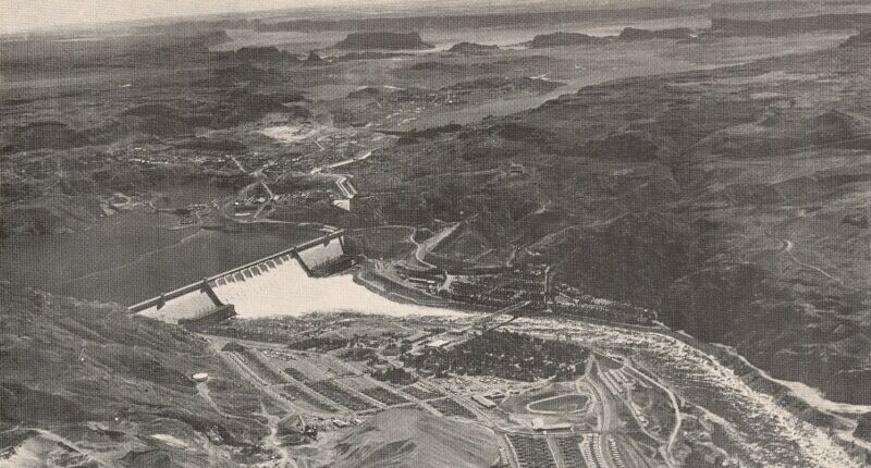
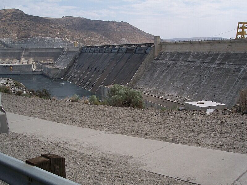
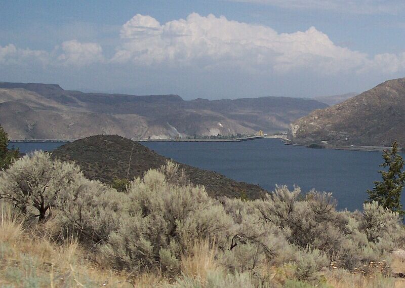
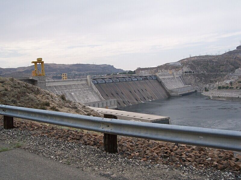
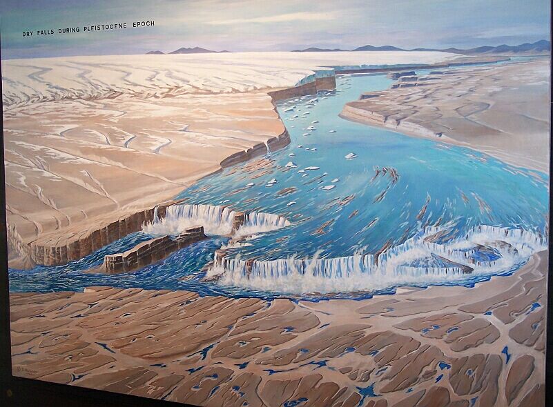
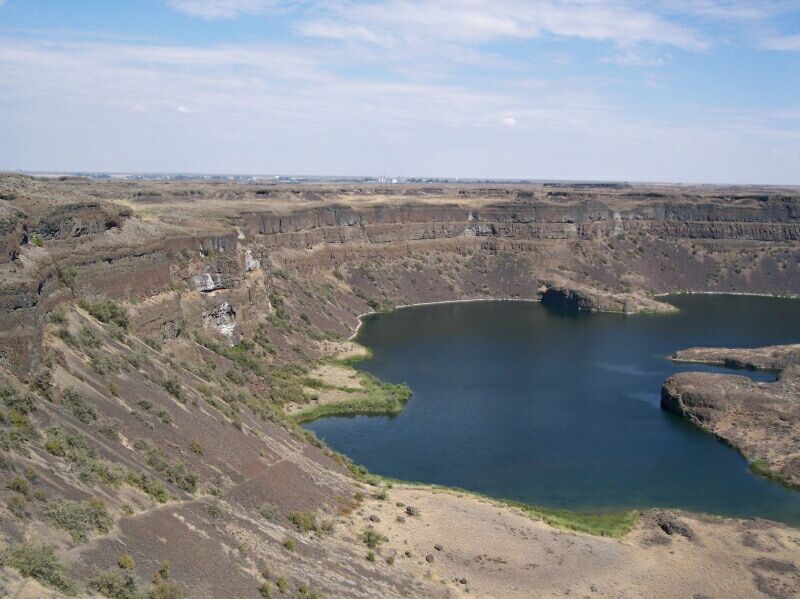
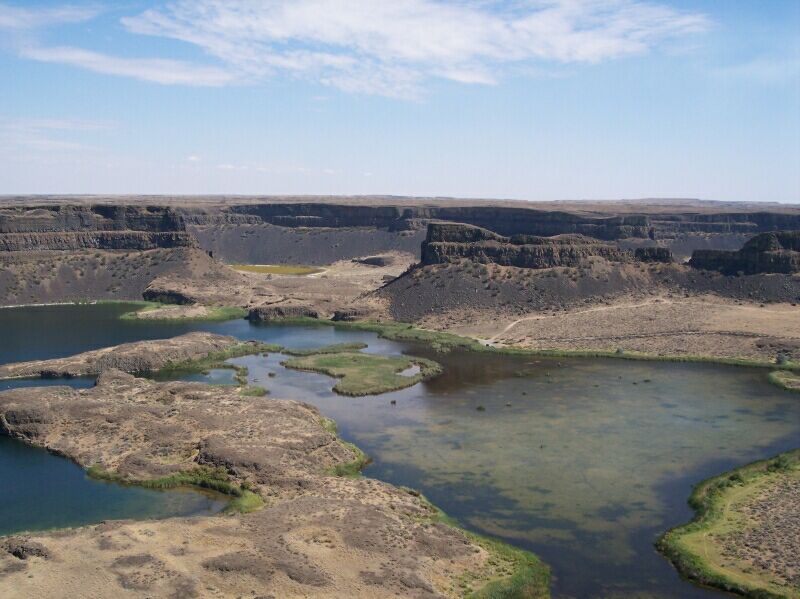
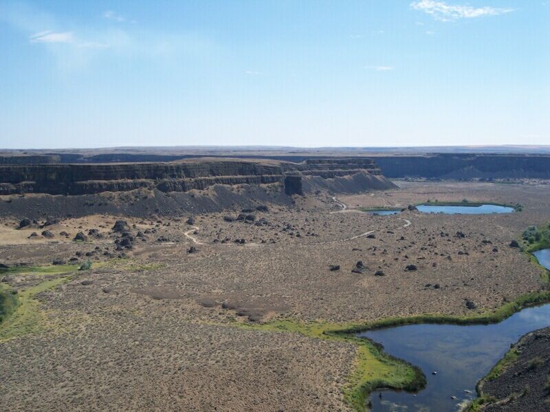
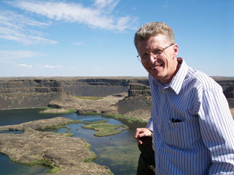
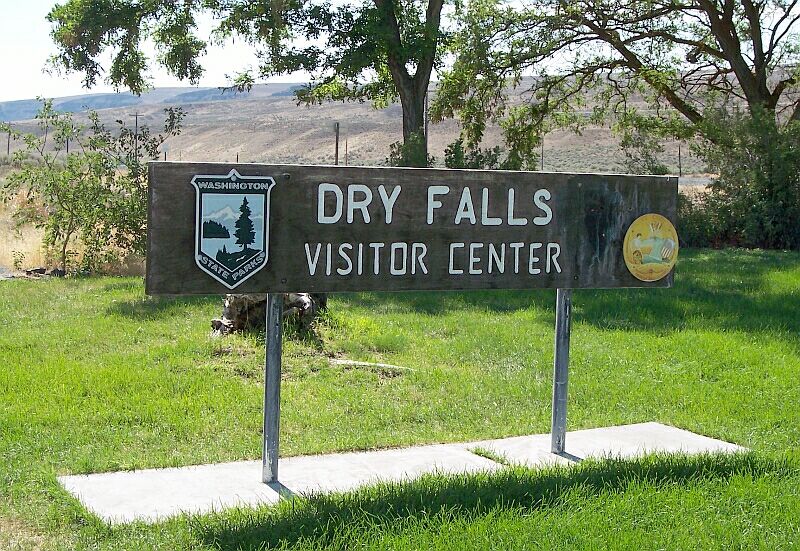
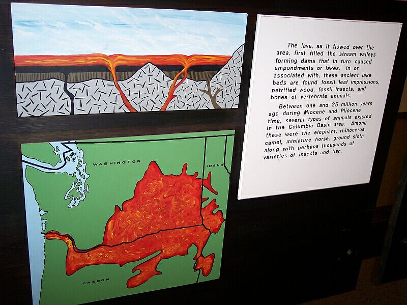
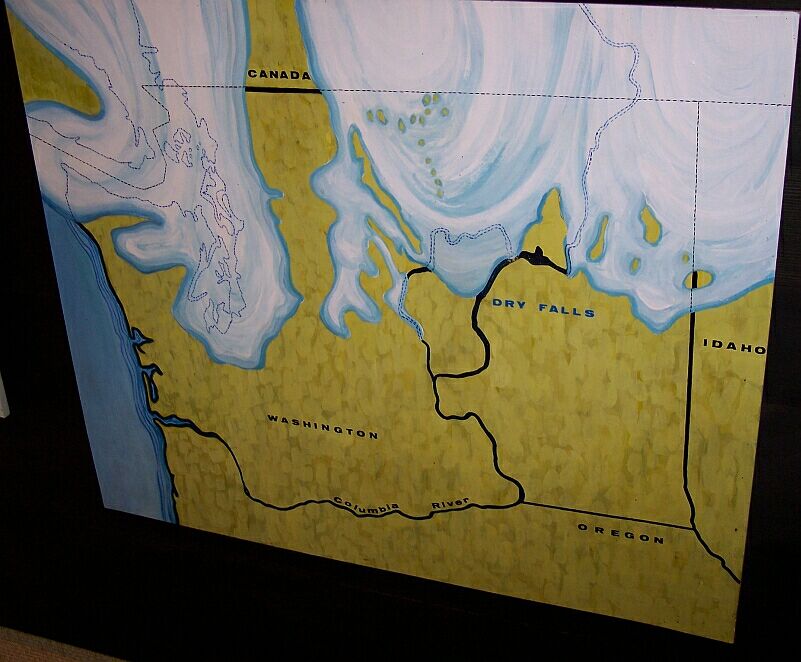
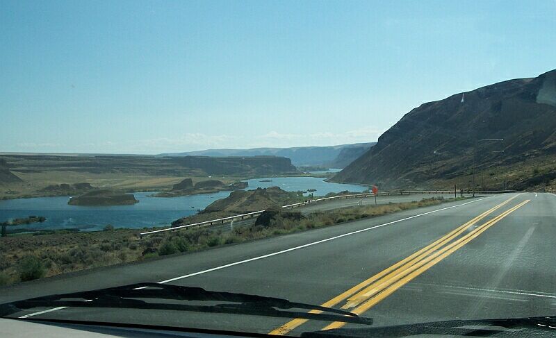
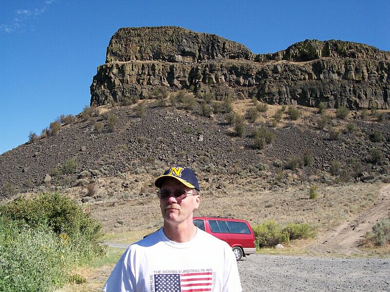
Week 169 Update

It was 05:30 in Spokane, Washington and 52º when I stepped up on our small traveling (Healthometer) Mr. Scale and he said, "186.5 pounds!"

Our week is over but we will carry the memories with us. It was a lot of fun! Dotti, Leroy and I all arrived on Saturday, and we almost immediately headed over to Costco for a quick bit of shopping and a Very Berry Sundae before they closed.

During these weeks, Dotti and Tammy often take off on shopping and other errands and we don't see them until the evening. So, my eating sometimes degrades to what I did on Sunday, where I had 2 cheeseburgers at lunch and another hamburger in the evening. Still my points were only 53.5 for the day, so I didn't go crazy.

On Monday, Jim and I did a bit of walking, even though the temperature was 98º outside. It all totaled up to about 1.2 miles, and we did it at a nice leisurely pace, so it was not bad at all. Just getting out and finally walking a bit was a very good thing. I did better on my points, only eating 42.0 that day, including a nice steak that Jim barbecued up on the grill outside.

Tuesday was probably my favorite day, although I enjoyed them all. We took a little trip to the Grand Coulee to see the Grand Coulee Dam, and Dry Falls. It was great!

The Grand Coulee is a huge trench that is cut into the volcanic basalt of central Washington State. It was cut by the water from the dammed Columbia River during the last ice age. Moses Coulee, a similar trench was cut to the west of the Grand Coulee earlier on, as the ice advanced southward damming the Columbia River at a more westerly point. However the ice finally dammed off that path as well and a new route was forced upon it.

At the Grand Coulee Dam we picked up a brochure with a picture on it that was looking south when the dam was first built. In it you can see what happened when the glacier came along and blocked the Columbia River right about where the dam is today. The glacier was much taller than the dam is, and the lake that it backed up, which is today called "Glacial Lake Columbia," was much deeper than Lake Roosevelt is behind the Grand Coulee Dam, and it covered an area that included all of the Spokane Valley and right into Idaho and today's Coeur d'Alene Lake. The level of Glacial Lake Columbia rose up to the point where it flowed right over the top of the ridge to the south and down what was then a river valley. It cut a path through the valley and made its way through this alternate path all the way down to where it joined up with its old river route and continued on its way. Down this valley it came to a very large drop off where it created a huge falls, much larger than Niagara Falls is today.

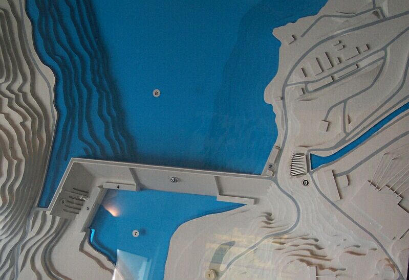
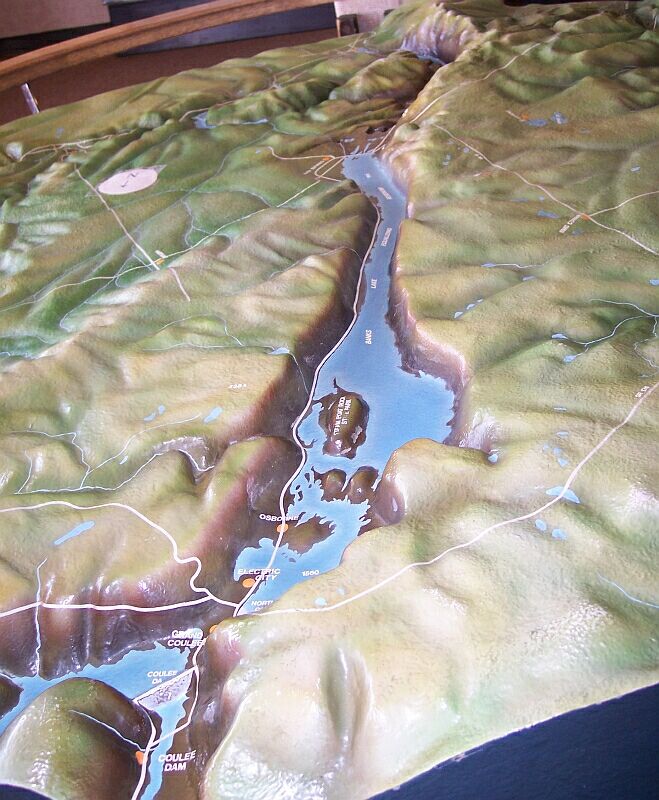
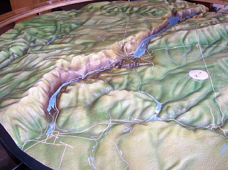
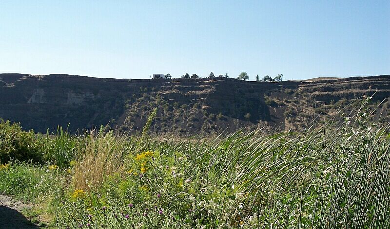
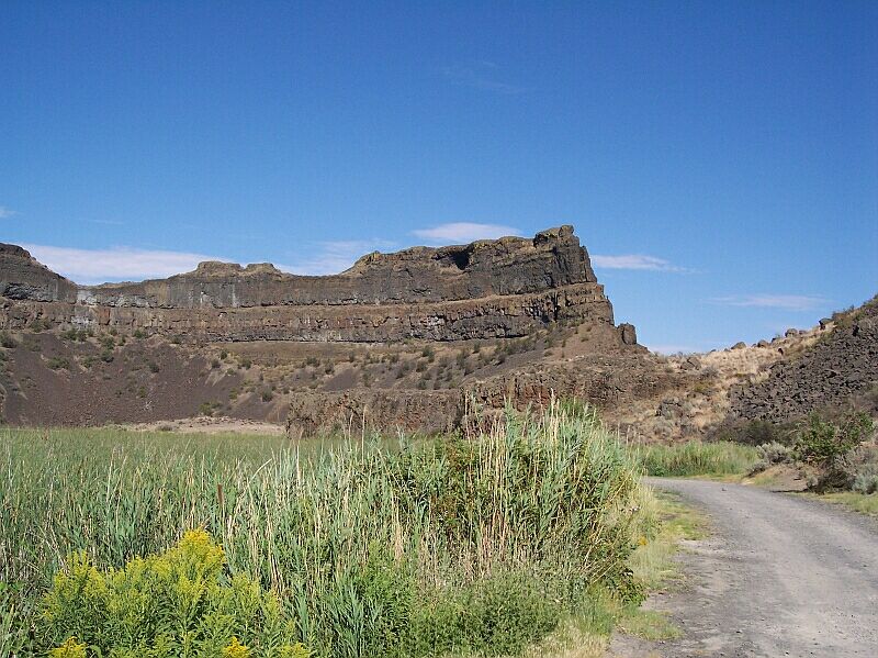
Then, towards the end of the ice age, there occurred a tremendous flood (several of them actually) that was released when Glacial Lake Missoula broke through its ice dam and sent 500 cubic miles of water gushing over central Washington. The bulk of that water came right over the top of this river valley where the Columbia was flowing, and it ripped the huge channel that you can see running off to the south. Even though it is 6 miles wide at points along its length, still it could not contain the water in places.

Later, when the glaciers retreated, the Columbia returned to its original path. The granite foundation of the mouth of the Grand Coulee proved too tough for the water, and it did not erode down to normal river level. So, that path was left high and dry, hundreds of feet in the air.

Today the Grand Coulee Dam forms a miniature replica of the old glacial dam and it backs up a much smaller lake behind it. While the lake is not deep enough to reach the Grand Coulee directly, the dam, which has the capacity to produce over 6,480 megawatts of power, uses some of its electrical power to drive pumps. These pumps move water from Lake Roosevelt up to the Grand Coulee, and thereby have created Banks Lake. (It was not yet in existence when this picture was taken.) They have built low dams at both ends of Banks Lake to keep it from draining. The water is used for irrigating the Columbia Plateau region of Washington, creating lush farms where desert was king not so long ago.

If you would like to find out more about the dam and its power output visit http://users.owt.com/chubbard/gcdam/html/hydro.html

This was actually one of the first glimpses that I received of the Grand Coulee Dam. We are looking over Lake Roosevelt at the new section of the dam. The old section runs to the left and out of the picture. On the right of the new water way you can see the bared and blasted section of granite that was shaped to make way for the new arrangement.

Here is the Grand Coulee Dam today. It was originally completed in 1942, when it looked just like you saw it in the first photo. However the dam was modified during the years of 1982 through 1988 and the north end of the dam was chopped off and replaced with a new section that runs nearly perpendicular to the original dam, extending the overall length of the dam from 4,173 feet to 5,223 feet, almost a mile. That new 1,100-foot section added a third powerhouse to the 550 feet tall dam, whose 6 generators easily out produce the other two older powerhouses, and the pumping plant combined, even with their 9 main generators, 3 Station Service Generators and 6 Pump Generators. However, when I questioned the tour guide, she said that the volume of water that they are using to power those 6 new generators is so great that they could not put any more of them online with the amount of water available from the Columbia River. They are about at the limit of what they can produce with the water available.

At the time that I took this picture I didn't realize that we would later be riding that elevator that is shown here near the bottom of its run. The parking lot for the dam tour is located above the concrete wall and to the left. You can see the fairly freshly cut granite running behind the concrete structures. That was all done during the 1980s work, to make way for the new dam section and water path behind it.

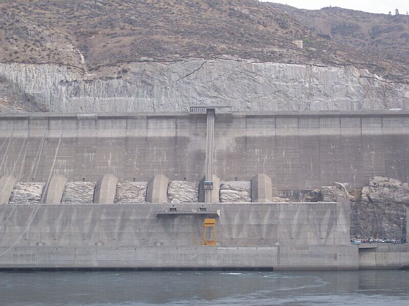
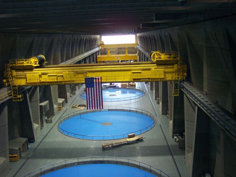
The 6 concrete tubes that you see are huge pipes or "penstocks" that direct high-pressure water into the 6 main generators of this new powerhouse. The guide said that you could drive 3 buses side by side down the middle of any one of those pipes. They are 40 feet wide right down to the bottom where they are reduced to 34 feet 8 inches.

The walls of the lower powerhouse structure have been specifically shaped to absorb the tremendous vibration caused by the generators. Later on, we would be coming out on the viewing platform that you can see right above the yellow crane, and the vibration was quite intense at that point. The "diamond" depressions were created as shock absorbers for that vibration.

This is a model in the information center that shows how the north end of the dam was modified from the original straight line design.

Here Dotti and Tammy are smiling for me, with the Columbia River and the Grand Coulee Dam behind them. Awesome!


Jamie gave me a smile too. You can tell the dam is interesting, but not as interesting as seeing her favorite Country singer in concert might be. Big Smile


I took this picture looking back up the side of the elevator we had just taken to get down to this level.


LeRoy loves eagles, and so I thought it would be good to catch him in front of this statue.


Looking back over the top of the dam towards the south and into the mouth of the Grand Coulee.

This is inside the new powerhouse looking west over the largest generators. The largest could supply all the power needs of the city of Seattle, all by itself.


We next headed down the Grand Coulee itself, and about 20 miles down the road we came to Coulee City, right near the dry falls.

It seemed just a little creepy driving through town, because it felt deserted. And the Hotel sign was missing most of the “O” and the windows just didn't seem quite right for August. Big Smile


I am all for Christmas, but it just felt weird as we were driving along.

Despite the Twilight Zone feel to the place, everyone in the car was getting hungry by this time and so we stopped at the Steamboat Rock Restaurant. The town seemed deserted and made us feel a bit creepy but the food was not too bad.

We all were having a good time, and laughing at ourselves for feeling so creepy in the town. It felt a bit like whistling through a graveyard, but the nervous laughter was fun.

Dotti is leaning back to say something to LeRoy while we waited for our food. Jamie and her girlfriend were sitting in the booth with LeRoy, while we parents were sitting in the next booth.

After leaving the restaurant, we drove the short distance to Dry Falls. I had encouraged the others to come here, because I had read that this is a geological feature that is unmatched anywhere on the planet. When Dry Falls was flowing it was an incredible thing, a true wonder of the world. More than twice the height of Niagra Falls, it was also 5 times as wide! The Columbia River flowed over this falls on its path to the Columbia River Gorge, and on to the Pacific Ocean. This "short circuit" of its ancient course, which was returned to later, was cause by a glacier blocking its path right where the Grand Coulee Dam is currently located.

While it was hot—up in the high 90's—on the day we visited the site, when the falls were in operation, it was a very cold place indeed!

Another fact about Dry Falls is that during the Bretz Floods, more water flowed over these falls than all the water in all of the rivers today, in fact it was more than TEN TIMES as much water as all the rivers carry today! Of course, at that time, the water was so deep that the falls themselves only caused a little ripple in the flow.

This is an artist's conception of what the falls might have looked like when Glacial Lake Columbia existed and Grand Coulee was handling its overflow. This would have been normal run off from the lake. The falls at this point is 5 times as wide as Niagara Falls, and it is 350 feet in height, more than twice the height of Niagra Falls!

The visitor's center is located near the top of the falls on the far left of this painting. Looking from our vantage point we could only see the leftmost portion of the horseshoe clearly and some of its right section. The long curved section on the right of the painting was blocked from view. It wasn't until we actually drove down to the bottom of the falls that we caught a glimpse of the largest part of the falls.

Notice the glacial ice in the background of the picture. The road we had just driven on went through where that ice field once lay.

Dry Falls and Niagra Falls are cousins really. They both were created by the last Ice Age (Wisconsin glacial advance), and while the passage of the period of glaciation (the Ice Age is technically still going on, since we have huge ice sheets still covering large areas of our planet), and the entering into an interglacial phase, left the Dry Falls, well, dry, Niagara Falls is still going strong, because the ice left behind incredibly large water-filled depressions cut into the bedrock, which form Lake Erie, which is the source of the Niagara River, and Lake Ontario, its destination.

Niagara Falls draws many visitors every year, while the Dry Falls is a mere curiosity for most people, and is virtually unknown to the general population. Niagara Falls is beautiful and wet, while Dry Falls is hot, arid, and more like a fossil than a falls.

You can call me a sentimentalist, or a fool, but I have been to both of these wonderful geological marvels, and it is Dry Falls that is the more marvelous to me. Perhaps it is because the Columbia River once flowed over it, or the fact that my imagination is set to reeling as I try and picture the various events of this silent testimony to the past. So many things went into making this falls, exciting things, incredible things, and things you cannot see anywhere else on earth today.

When I look at this picture, taken from beside the visitor's center, I see cataclysms. Chronologically first is the great Columbia River Basalt flow, the second largest that ever occurred on this planet. This tremendous event, covered 63,000 square miles of the Pacific Northwest. (That is enough to cover the entire states of Maryland, Vermont, New Hampshire, Massachusetts, New Jersey, Hawaii, Connecticut, Delaware, and Rhode Island, combined, with enough still left over to do Connecticut, Delaware and part of Rhode Island again! It was a enough to cover the entire state of any of the United States east of the Mississippi. With the exception of only the 4 largest states, if this flow were poured over ANY of the states of the USA, it would have buried more than half of its land surface.) If this amazing lava flow had been restricted to the state of Washington alone, it would have covered almost all of its surface. But it was shared between Oregon, Washington and Idaho.

Another thing about the Columbia River Basalt: it was up to 6,000 feet thick in many places. It filled the Columbia River Gorge nearly to its top, and it covered the area where Spokane is today, as well as reaching clear to the Pacific Ocean. You can see the layering that was created as the basalt cooled, all along the wall of the Dry Falls. This was of course, very old news by the time the Wisconsin glaciation of the Ice Age hit.

The Ice Age blocking of the Columbia River, redirecting its course over this particular spot is the second cataclysm I see here. Glaciers damming the Columbia, forming the great Lake Columbia, and then allowing that lake to rise to the point of breaking over the threshold of the Grand Coulee entrance, caused these falls to form.

At the base of the falls, the dropping pools, created by the tremendous force of huge amounts of water falling for 350 feet before hitting bottom, are covered by this small lake which formed over them.

A third cataclysm, is shown by the fact that we see the falls here, and not 15 miles downstream from here! The basalt foundation of the Grand Coulee was torn up by the tremendous flow of water from the Bretz Floods (also called the Spokane Floods, or Lake Missoula Floods), and it moved the falls back from its original location, 15 miles upstream to end right here. (By contrast, during the thousands of years that the Niagara Falls has existed, it has moved less than half that far: a mere 6.8 miles.)

Not only did the area where Spokane, Washington now sits get covered by the Columbia River Basalt, but later the Bretz Floods went right over the top of it, temporarily burying the future location of Washington's second largest city under 500 feet of water! Dry Falls and Spokane share a lot it seems.

It is hard to believe that all of this was once under water that was flowing at an incredible rate. Now it is hot, dry and arid desert land.

Looking downstream, the land looks brown and nearly dead, except for the green strips surrounding the puddles of water left standing in depressions cut by the old river's flow.

Here I am with this geological marvel behind me. When water flows strongly over a falls, it wears the surface unevenly, causing horseshoe shapes to form, and leaves protrusions of rock that fail to drop into the maelstrom. As Dry Falls cut the rock back, it left some standing islands in its wake, and today they are silent reminders of the tremendous forces once at work, but that are now long gone.

This sign might as well say "Death Valley" from the way the terrain in the distance appears. This sign is weathered, more by sun and wind than by water. It seems just right for Dry Falls.

Inside the visitor's center, my best friend Jim has found a Navy Jet! It was a surprise to find the Blue Angels at Dry Falls, but Jim was a jet mechanic in the Navy, and he loved doing it! So, if anyone was going to find this model, it would be Jim.Big Smile

In the visitor's center I spotted this display that shows the flow of the Columbia River Basalt and the extent of its coverage. It simply boggles the mind trying to envision what it must have been like at the time.

First fire, and then ice. Our geology in Washington has been formed by these two forces, over and over again. This picture shows the area covered by glaciers during the last glacial advance, and how the Columbia River was diverted over the Dry Falls down the Grand Coulee route.

If you look to the left of Dry Falls, there is a second path that is drawn in with dashed lines. That is the Columbia River's normal course, the one it takes today. You can see how the glaciers moved down and blocked its path, forcing the water down the Grand Coulee.

Further to the left, the Puget Sound area is buried by ice, putting all of Seattle, and Victoria under thick sheets of it. The ice didn't quite reach down to the Portland/Vacouver area, but I'll bet it was mighty cold there anyway.

On the right side of this drawing you can see the way the glacier pushed down into Idaho, and that blocked the Clark Fork River, and caused Lake Missoula to form to the east, and that was the source of water for the Bretz Floods!

Here is a model of the Grand Coulee, with the Grand Coulee Dam at the lower left corner of the picture. Dry Falls is at the other end of the coulee, just past the blue of Banks Lake. The Grand Coulee Dam uses some of the power it generates to pump water up from the Columbia River and into the artificially created Banks Lake. The dam on the Dry Falls end of the lake keeps the water from continuing on over the falls. This water is used to irrigate the surrounding desert-land and allows farming to take place that would otherwise be impossible.

This is the Dry Falls end of the model, and you can see Coulee City, where we had lunch, clearly marked.

Here you can see the entire length of the Grand Coulee detour that once was the path for the mighty Columbia River. At the top right is where the Grand Coulee Dam is located, and at the lower left, the Grand Coulee empties out into Soap Lake. The current path of the Columbia River lies to the south west of Soap Lake.

Google's terrain view of this area shows the end of Banks lake, and Coulee City just southeast of the dam. Moving to the southwest, the Dry Falls is shown, and downstream from that is Park Lake.

Zooming in on Dry Falls, the names are shown for the various lakes formed in the depressions cut by the water's motion when the falls were active. The visitor's center is to the west of Dry Falls Lake, and we later drove down into the riverbed, past Pearch Lake, to end up between where the visitor's center stands and Umatilla Rock near the edge of Dry Falls Lake.

Moving to the other end of Grand Coulee, the terrain is shown and north end of Banks lake is at around 1600 feet elevation, while the dam is at 1200 feet.

We next drove south a bit towards Park Lake, visible off to the left through our windshield, but before we actually got to it, we doubled back and went down into the ancient bed of the river. Jim and Tammy have a 4-wheel drive van, and Jim was kind enough to take us over to the base of the falls.

Situated on the rim, 350 feet above us, the visitor's center, where we had just been, looks lonely and small. The layers of basalt stand out sharply in the sun and shadows, with grass growing in the foreground, where once some of the most powerful forces ever unleashed on planet earth had been spent.

Looking up at the brink, where ancient lava had stood for so long, before water ripped it back to this point, and left it reformed into a layered wall, baking in the sun and backed by the blue sky, and few whips of clouds. This dirt road crosses ground that has felt the fiery wrath of the deep and the watery anger of ice, but safely passes by grass and greenery, as if it were just like any other place else on earth.

Another thought in this vein: the monster volcano that brews menacingly beneath the wondrous and beautiful Yellowstone Park, may have been created at the same time as the lava flowed over this very land. The hot spot sitting beneath the famous Yellowstone Park, might have been created by a comet strike that produced the rock we are looking at here. It seems a long ways to Yellowstone, but, at least geologically, it may be not so far after all.

Jim looks up at the visitor's center, while LeRoy and the ladies are resting in the cool car behind him. Above stands Umatilla Rock, a rock fortress, laid down long ago, and ripped into shape by a torrent of water that we can only wonder at today. I don't know about you, but I am awed by the forces that shaped this place. I am so glad we came to visit Dry Falls!

3 years, 88 days OP; a lifetime to follow.

-Al-

6 '3" 239.5/186.5/180±2/BMI:23.31/WK-169
GRAPHS: Weight Loss/Year 1 Maint./Year 2 Maint./Year 3 Maint./Miles Walked
                Success Story


[ON TO WEEK 170] [BACK TO WEEK 168] [STATISTICS PAGE] [TABLE OF CONTENTS PAGE]